Saturday 29 January 2011

Clachnaben via Glen Dye

28th January 2011

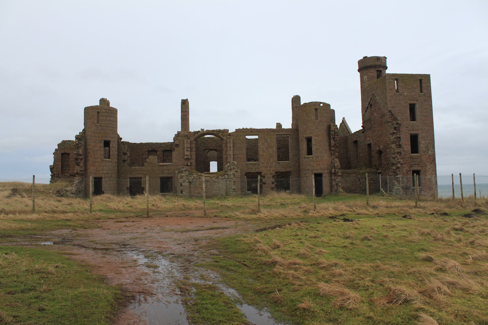
We always know where we're going and what we're going to do before we set off, but we also try to leave as many options, as to the details of what we're going to do once we get there, open as possible. In this case we had decided during the week that we would go to Glen Dye but it would depend on the weather and how we were feeling as to what we would do once we got there. I'm explaining all this because this turned into a much longer, and more strenuous, walk than perhaps we envisaged. When we go to Glen Dye we park at the bridge over the Spital Burn, which is a tributary of the Water of Dye, about 6 miles from the village of Strachan (pronounced Stra-an), on the Cairn o' Mounth road. My guidebook tells me that the term Spital refers to a hospice that once stood on the site and goes on to say that it later became a notorious public house "a haunt of thieves and robbers". But all that's left now is an old ruined cottage.

Ruined Cottage

We set off from the car at 09.30, which is quite early for us, and the temperature was (-)3. It was cloudy but crisp and the weather forecast was for a "getting better" kind of a day. We were just about to set off when a group of about a dozen men appeared, all well equipped and looking very purposeful. It was only after we had left the car and came across their vehicles that we realised they were from the RAF and Braemar Mountain Rescue units and were probably on an exercise of some kind. Leaving the road we walked down the track, crossing the Water of Dye just beyond a high fence and locked gate. The style here is as awkward as styles get but was nothing compared to the other adventures to come. In the past I've always photographed Clachnaben from the bridge but today it was shrouded in mist. Still the weather forecast promised better.

Mountain Rescue, (feeling safer already!)

Just after the bridge we turned left and headed up the glen, generally following the Water of Dye upstream. The wooded area on the other side of the river gives way to moorland and heather as we followed the track further into the glen. The basic walk we had planned for the day was to walk into the Charr Bothy along the low track then back over the high track to make a circular route. The problem with this plan was mainly to do with time. If we did the basic walk we could be back at the car in under two hours. We chatted about this as we walked in and decided that we would add something on, but that we'd leave off making the decision until after we'd had our coffee at the bothy.

Looking back the way we'd come

About halfway to the bothy, though a gap in the hills, we got our first glimpse of Clachnaben, still with a light covering of mist but, as the weather forecasters promised, it looked to be clearing. Also at this point there's evidence of habitation, with lots of crumbling stane dykes and what looks like a ruined cottage. There's also a great solitary pine tree that gives the impression of having been there forever. There is a local legend that a notorious warlock by the name of Colin Massie lived in Glen Dye, in a cottage where the lone tree stood, with his mother and brother, (although I must confess that a notorious warlock called Colin living with his Mum doesn't sound all that notorious). Anyway whether this is the spot or not I'm not sure but I still think the tree is great!

Lone pine with Clachnaben behind

Shortly after the lone pine we came to one of these strange man-made things that you come across from time to time out in the middle of nowhere. In this case it's a small Scottish Water reservoir but I have no idea what or where the reservoir serves. The one notable thing about it though is the sign that tells us that it's the Glen Dye Raw Water Reservoir. I just love the term Raw Water!!

Raw Water!!

From the reservoir it's only a short walk to the Charr Bothy. I must say that I've never stayed overnight in a bothy but if it ever became a necessity I'd like to stay in one like this. The buildings were donated by the Fasque Estates to the Mountain Bothies Association, (MBA), with funding provided by the family and friends of the late John Whitley. We made ourselves comfortable and had a coffee and some chocolate of course, while we decided what we wanted to do next. The bothy sits on a crossroads where the Water of Charr joins the water of Dye, so from where we had come from we had three choices. Left would take us up into the hills, eventually joining the road again at the top of the Cairn o' Mounth; straight ahead leads, if you walk far enough, to Glen Esk or can also be used as a route to Mount Battock, the 778m high Corbett at the head of the glen; and right would take us up over a couple of small tops before coming to a junction where we could go to Clachnaben or if we were to carry on we would meet up with the Mount Battock route.

Coffee in Comfort


Charr Bothy

In the end we decided it was time to put a bit of effort into our walking after the last couple of weeks of coastal walks with tea and cake, so we headed up towards Clachnaben. Now I know what you're thinking; these two tops and even Clachnaben are not particularly high, but you need to remember that we haven't climbed anything higher than the stairs for the last 18 months, so any uphill effort was going to get the heart pumping. So with a steady plod we set off up towards the first of our little tops, the Cairn on Finglenny at 469 metres. The path wound its way up and for the first time we began to get patches of snow underfoot. The cairn itself meant that we had to leave the main path, but it was worth it for the views back to where we'd come from and across to the now clear Clachnaben.

The slog - with the Bothy in the background


Cairn of Finglenny

Clachnaben

From the cairn there was a flat then downhill section before we began another uphill slog towards the second of the tops, Hill of Edendocher at 577 metres. This section seen us walking on snow for a good bit of the way but this was no real problem since it was hard-packed and gave good grip. Looking down through some of the holes it was amazing how deep it still was and did leave us a wee bit wary of walking too close to the edges of the path just in case. The top at Hill of Edendocher was a bit indistinct apart from the granite outcrop a little way off the path and what looks to all intents and purposes a car parking area! However it did give some good views over to the snow covered Mount Battock.

Mount Battock

From here it's only a short flat walk to the turn off to Clachnaben and the next decision we needed to take. In the end it wasn't really a difficult decision since it was now around one thirty and it seemed sensible to start making our way back to the car rather than walking further away from it. The downside of this decision of course is that we now had another stiffish climb up to the top, and the concern about what the path down from the top might be like.

Path towards Clachnaben

Clachnaben is giant granite tor that can be seen from most places on Lower Deeside. At its tallest its cliffs are 29m high but there is relatively easy access up to the top from the west side. On the O & S map there are two heights shown - 579 and 589 metres - and I assume the lower height is the trig point and the higher the top of the tor. As we approached the top we saw a couple of people on the top and these were the first, apart from the mountain rescue people before we set off, that we had seen all day.

On the top of Clachnaben

Despite the relatively easy scramble to the top of the tor, I was a wee bit reluctant because of the snow underfoot but Mo was for none of it so we clambered and slipped and cursed our way up and I must say the views are spectacular.


From the top

My fears as to the condition of the path down from the top were only partially borne out in that it was really icy near the top but as we dropped down it became more and more secure underfoot. It's worth mentioning here the great work done by the Clachnaben Path Trust who built and now maintain the path. It's easy underfoot with good solid steps where needed. We were just beginning to feel really pleased with ourselves when we came to a steep area where the snow covered the path for about 50 metres.

Snowy descent!

People had obviously passed this way before because there were plenty of footprints chipped out of the hard-packed snow but it was still quite exciting traversing the hill before making our way down through the heather to the path. From here it was a pleasant walk down through the forest with some nice views of Clachnaben against a sky that was now quite blue. So the weather forecasters got it right.

Looking back

 We stopped for a while where we exited from the trees at a nice seat in memory of one Heidi Jane Fish who died aged only 17. I have no idea who the young lady was or why she died so young, but her family picked a nice spot for her seat. From this spot it's a long flat walk back to the car and as ever when you know you're nearly finished, we were beginning to feel very tired as we re-crossed the Water of Dye and the dodgy style. I did however take time out to take one last photo of where we'd been.

Last look

So that was the end of a long, tiring but ultimately, satisfying day. We left the car at 09.30 and arrived back at 16.30.

Just a quick mention of the Robert Smith Guidebook 25 Walks on Deeside for his story about the hospice / public house and Colin the Warlock of Glen Dye.

J


Saturday 22 January 2011

Muir of Dinnet - Burn O' Vat & Loch Kinord Circuit

21st January 2011

After a couple of walks along the coast, we were quite keen to go a little bit inland - despite my exploits in Glen Tanner. We were hoping that with the continuing thaw that the paths would be a bit less treacherous and decided on the Muir of Dinnet nature reserve on Deeside. One of the nice things about walking in Deeside is the pleasant drive and, since we were in the car before nine o'clock, we were able to take our time. When we first moved over to Aberdeen, we had spent quite a bit of time exploring the areas and roads between home and Braemar and one of these roads we christened "the rabbit road" because everytime we travelled along it there seemed to be hundreds of them. Over the last few years however we have tended to see fewer and fewer. The other reason of course is the views down the Dee valley towards Clachnaben and the snow topped Cairngorms beyond.

Clachnaben

The starting point for our outing today was the information centre that sits on the A97 road a mile or so from the north Deeside road, (A93). As ever at these places the information centre, exhibition and toilets were very good and well maintained.


Muir of Dinnet information centre

The Muir of Dinnet is a National Nature Reserve that takes in the lochs of Kinord and Davan with the hills of Culblean sloping down to the western shores. The information centre suggests three separate walks but in the end we did the best parts of them all! We started by following the trail to the Burn O' Vat which is the remains of a collapsed cave formed by meltwater after the last ice age. The path was generally clear with only one or two areas that gave us some concern and Mo decided that the last bit was too risky for her. I carried on and followed the stepping stones up along the stream and through the narrow entrance into the Vat.

Burn O' Vat Entrance

Once through the narrow entrance the huge bowl like cave with no roof and a waterfall cascading into the far end. It's a fairly impressive sight with the lower parts of the wall undercut with the water scouring. Our guide book suggests that it may have harboured many a fugitive and certainly the narrow entrance would have made it easily defensible. The most famous of these was one Gilderoy MacGregor who was said to have held out here for a while. He was eventually captured and hanged in 1658.

Inside the Vat looking back to the entrance

After visiting the Vat we retraced our steps for a wee while before turning up a separate path that works its way up through the trees to a view point that looks east out over Loch Kinord. The information board tells us that lochs Kinord and its neighbour Davan were formed when great chunks of ice broke from the receding glacier and as the these chunks settled into the landscape and melted over the next decades they left "kettle holes" that filled up to become the lochs we see today.

Loch Kinnord

We ended this, the first waymarked walk, back at the visitor centre. From there we crossed the road and onto a well maintained path. We decided on an anti-clockwise circuit of the loch because we wanted to add in a part of the third waymarked walk. The path winds its way through what looks like birch trees past lots of little lochans that we decided were actually marshy areas in the summer but because of the recent weather had become flooded. We were also reminded about how cold it had been when we realised that all of them were still frozen.

Frozen Marshes

Once clear of the marshy areas its only a short, easy walk along good paths until you come to the banks of Loch Kinord itself. There's evidence of early habitation with the usual piles of stones that vaguely take the shape of a cottage or farm building. In one of the descriptions I read about this walk it talks of an old chapel but none of the guide books mention a chapel and there is nothing marked on the O&S map, (which I had with me, of course). There was however a castellated building that has a cross at the pitch of one of the gables but whether or not this is simply a coincidence I don't know.

Chapel Connections (??)

Just past this building there's a seat where we stopped for a coffee and some chocolate. The loch was iced over and of course we dug out some stones from the still frozen ground and threw them out onto the loch to try and break the ice. Well you do don't you, and don't deny it! Anyway it was still solid and a really strange milky colour. It was also incredibly slippery, (I had a walk out a few paces but there's always that voice in your head telling you not to be so stupid - or was that Mo shouting at me!). The path meanders around the edge of the loch for a while and we passed a man on his own working away on path repairs. How do you get a job like that? I had checked the O&S map before we left, looking for anything marked up on our proposed route that the guide books don't mention. The only thing of note was "earthworks" that were shown around this part of the loch shore. Despite having walked this route a couple of times before, I couldn't place where this would be so had already decided that there would be nothing to see of these earthworks. I was wrong.

Earthworks

As I said we have walked this route on a number of occasions and although I've noticed these before I had never given any consideration as to what it might be. We still don't know of course but we took the time to climb to the top and have a look round. There was nothing to see as such but the top was flat and grassy and gave a good view down the length of the loch. We carried on, following the path as it winds in and out of the various inlets, taking photographs and speculating about what it must have been like to live out your life with only mud huts and your own ingenuity to keep you alive. Conclusion? We would have died!! As we rounded the head of the loch we stopped at another of the information boards that detailed all that is left of the Crannog island a hundred yards or so offshore.

Crannog Island

The crannog dates back around 2500 years and, although it's hard to believe, probably sheltered 20 to 30 people and their animals. From here we left the Loch Kinord path and, heading directly away from the loch, picked up the Muir trail. This is the third waymarked walk in the area and it took us into the heart of the Muir. The reason for this particular detour was to try to pick out the "hut circles" marked on the O&S map. This was made really easy for us by the information board that not only pointed them out but gave us some information as well! They were dated to the Iron Age between 2500 and 3000 years ago and the people who lived in them lived by hunting and fishing and by growing some kale and oats.

Iron Age Hut Circles

The path from here wanders through more trees and heather covered clearings past the long abandoned Old Kinord farm, finally emerging onto a farm track. From here we turned left, back towards Loch Kinord because there were still a couple of things we needed to see. The first was a Celtic Cross that had been discovered sometime around 1820 and moved to Aboyne castle but returned here in 1957. The Cross is carved from a solid piece of granite and is around 1200 years old. Its presence suggests that there was a chapel or small monastery of some kind but there is no indication as to where this might have been.

Celtic Cross

We followed the path a little further down towards the loch to have a look at the man-made island a little way offshore. The island was built 900 years ago by King Malcolm Canmore who came here to hunt deer in the woods. He stayed in a wooden tower on the island and as time passed this was replaced with a stone one and a causeway was built from the shore. It's claimed that Edward I stayed here while his army camped on the moor and that James IV spent a couple of nights in the castle in 1504. Many years later, once the tower was gone, local people grazed their wildlife on the island, but now it sits empty except for wildlife.

King Malcolm's Island

From the island we retraced our steps back up the hill. The path here winds its way through lichen covered trees and this is, unfortunately, as close to Loch Davan that we get on this walk. Loch Davan is rich in wildlife and as many as 24,000 wintering geese have been seen here as well as mute and whooper swans.

Loch Davan

The path continues on finally arriving back at the road. Here we took another slight diversion to visit the memorial stone raised in memory of the Battle of Culblean that took place on St Andrew's day 1335 and was considered the turning point in the second Scottish war of independence. Personally I admit that I'd never heard of such a battle but maybe that's more a failing of the sixties education when it came to Scottish history than on my ignorance.


Battle of Culblean Memorial

From here it was only a short walk back to the information centre. We had a quick look round the exhibition, (I guess we should probably have done that before we set off!). We were away for about three and a half hours but as ever we took our time as well as a lot of photographs!!

J

Sunday 16 January 2011

Slains Castle

15th January 2011

A bit of an explanation needed before I start this post I think. This is a wee bit unusual in that it's not a "long" walk, but I wanted to include it because it's unlikely that we'll ever do Slains Castle under different circumstances. John and Craig are off to Amsterdam for the weekend so Mo and I were drafted to do a bit of dog sitting. There are two dogs, both cocker spaniels and both have more energy than Mo and I put together! The usual routine when we're looking after them is that they get a long walk in the morning and then periodic visits to the back garden in the afternoon for a bit of messing about.


Freddie & Dougal

The long morning walk today started around half past eleven at the carpark in Cruden Bay on the way down to the harbour where the route starts out along a muddy track through some scrubby looking trees. The path runs alongside then crosses a stream, (can't find a name for it). At the bridge the path splits into three; on the right it leads up onto what, among ourselves, we call the moors; straight ahead which is our return route; and left up a short sharp hill to join a path running alongside a ploughed field.

Turn left dogs!!

Once up the hill it's only a short distance from there to a farm track that heads up to join the path to Slains Castle. The internet of course is full of stuff on Slains castle, mainly because of its links with Bram Stoker's Dracula. The story goes that Stoker, who used to holiday at the Kilmarnock Arms in Cruden Bay, christened the castle "The Castle of Death" and it became the blueprint for Count Dracula's castle, located somewhere in Transylvania. How much of this is truth and how much is urban myth I honestly don't know, but what I do know is that it's a very impressive structure.

Slains Castle

I've walked round, and photographed, the castle on many occasions and, as you do with lots of old ruins, I always struggled to picture what it must have looked like in its glory days. I was pleased therefore to find a pictorial representation when I was searching through the internet reading up on the history of the place. The biggest surprise was the gardens that appeared to have been laid out on the clifftop, so we had a look at that area today and, although it was difficult to come up with anything positive, it certainly made us look at the area in a different light. To give you an idea of what I'm getting at I've laid out two photos below showing what it looked like in its glory days and, from roughly the same spot, what it looks like today.


The representation of the castle in its glory days came from here and the site contains some good background information on the castle's history.
From the castle we carried on down the path, heading back towards the bridge over the unnamed stream near the start of our walk. About halfway down there's a derelict tower which may or may not be part of the castle buildings, but I have no way of knowing. I guess that any of the buildings in this area will have some connection with the castle.

Mystery Tower

At the bottom of the hill we recrossed the stream and headed up onto the moors. The area up here is actually overgrown scrub-land that's criss-crossed with paths and motorcycle tracks. It's a great place for the dogs, with lots of open spaces and the occasional gorse bush for them to explore. It also has the great name of Goats Hillock. As well as the scrub and gorse, there's also the remains of what looks like a Second World War military installation. Whether it was an observation post or some other sort of defence area I don't know, but I'm pretty sure that I read somewhere that there was some worry at the time that, if there was to be a seaborne invasion of Britain, then the long sandy beaches at Cruden Bay were a likely spot.

Old Military Installations

The other thing the moors are good for of course is the view back along the cliffs to the castle. From this position, and especially if the light is right, you can see why Bram Stoker might have been inspired by the Castle of Death!!

Looking back to Slains

There are also great views of the cliffs and especially so today since it was very windy. We then left the path we would normally follow so that we could pass above the harbour and enjoy the view along a very windswept beach. It's strange how different the shoreline is either side of the Water of Cruden with the cliffs, (the Bullers of Buchan), marching north to Peterhead, while to the south there are sandy beaches all the way to Aberdeen.

Cruden Bay Harbour & Beach

From here it's an easy walk back through the scrub-land down to the bridge then along the still muddy track to the car. In all the walk takes about an hour and a half but of course it took a little longer than that today because we stopped to take plenty of photos!!

J

Saturday 15 January 2011

Inverbervie & Benholm Circuit

14th January 2011

There was a fair bit of discussion in the run up to this walk. After my experiences in Glen Tanner last week I was reluctant to risk going inland to find that it was still as treacherous under foot, however, even though the snow has all gone from along the coast, the weather forecast was threatening mist and rain. In the end we decided on sticking to the coast and hoped that the forecast wouldn't be as bad as they threatened. We had done this walk in the summer of last year on a beautiful day and, although the weather when we set off looked overcast, it would turn out to be a pleasant stroll.

We set of from the car park close to the Inverbervie sports centre at about 10 o'clock and our route was south along the old railway line towards Gourdon. On the right just after the start on the top of some low cliffs is the site of the 14th century Hallgreen Castle. There's little to see that would confirm that it ever existed apart from what looks like an old bridge set up on the cliff.

Hallgreen Castle ruins (?)

Further along from this there are more buildings but they look much later than the 14th century, (although I'm not sure what a 14th century building might look like). The weather was holding up nicely as we made our way towards Gourdon although it looked nicer back towards Inverbervie than it did towards Gourdon.

Looking back to Inverebervie

The path at this stage is flat and well maintained although there were some spectacular puddles and some very boggy patches. Still it was a lot better than the adventure on the ice last week. Inverbervie and Gourdon are very close to each other and I'm pretty sure that in days to come they will meet somewhere in the middle. According to the guide book we were to pass the buildings that had housed Britain's last working flax spinning mill which had closed in 1997.

Old flax spinning mill

There was no indication on the buildings to tell what they had been but the yellow sign on one of the doors read "DANGER beware of falling bales - SHOUT before entering" so to me that was enough evidence! From there the route wove its way through the village until we came to the harbour. No doubt in the past this would have been a busy place but I believe that it's mainly shellfish that's landed here now, although there is a smokehouse and what looks like a fish processing business complete with shop. We stopped to take photographs and it looked to my untrained eye that there were two harbours with an older one on the right and the more modern one on the left, (looking at them with the sea at your back).


Gourdon Harbour

From here the route picks up the Scottish Coastal Path network again, but continues to run parallel with the old railway line. I'm not sure why there are two paths because the old railway line looks perfectly passable as well, but maybe there's politics involved somewhere! The next half hour or so with fields on our right and the rocky shoreline on our left was a bit monotonous but we stopped for a cup of coffee and a chocolate biscuit, which is never a bad thing!

Looking South

After another fifteen minutes or so we came to half a dozen cottages - Haughs of Benholm - where we turn away from the seaside and head inland and up towards the main road to Montrose. The cottages looked great although we were a little bit concerned about quite how close they were to the shoreline. There must be a few wild days and nights where the sea seems a little too close for comfort. The one thing worth photographing at the cottages was this great old fashioned gypsy caravan. I wonder what its history is.

Gypsy Caravan

Once across the Montrose road we headed up towards Benholm Mill which is the last working water mill in Kincardine. There's been a mill on the site for at least 500 years and was in use until 1982. It has since been restored and is now a visitor attraction complete with waterwheel, museum, shop and tearoom. Well worth a visit! The last time we did this walk it was on a Sunday and the site was closed but this time it was open and the tearoom proved too tempting, (I recommend the apple cake).

Waterwheel


Mill Dam

From the mill the route goes on along the road for half a mile or so to the bridge over the river where we were to turn right. However the woman who runs the tearoom suggested that we crossed the river into the village of Benholm and visit the historical church. She also said that it was usually open to visitors and that it was well worth a look. We were a bit uncertain about what a historical church was but decided that it was worth  a look and, as it turned out, it was very interesting.

Benholm's historical church

Benholm's historical church

If I'm being honest I'd never heard of the church but apparently it became redundant in 2003 when the parishes of Bervie, Johnshaven, Benholm and St Cyrus were combined. If you want to read a bit more about its history try this link - Benholm Church - Anyway we had a good look round, including a seat in the pews reserved for the original gentry of the district, then a stroll around the graveyard and some more photos before rejoining our route. Back across the bridge we headed up a farm track that was once the old coach road some 200 years ago. It's a long pull up the hill, (known locally as the Lang Rig), but it's fairly easy walking on good track. The views back over our shoulder, (to the South), back along the coast to Red Head some 16 miles away were good topped with a great sky.

South to Red Head

You may recall in my post on the Boswell Tower walk that had been annoyed with myself for not taking an O&S map with me, fortunately I remembered to take one this time. On the walk up the Lang Rig the map suggested two things of interest. The first was a fort but, as might be expected, there was no sign of anything recognisable. On the upside the second thing, called "Long Cairn" was, rather surprisingly, where the map said it was. On the downside it wasn't much to see, just a long mound of grass covered stones, but at least it was there.

Long Cairn

From Long Cairn it's an easy walk back down to Inverbervie and back across the Montrose road at the wonderfully named Sillyflatt farm. From here we continued straight through the town past the world famous Bervie Chipper - it was closed so no need to fight off temptation - to get to the memorial to Hurcules Linton designer of the Cutty Sark, currently parked up at Greenwich, and Inverbervie's most famous son. The memorial itself is a full-scale replica of the ship's figurehead that was carved from his original drawings. It depicts a comely young witch from Rabbie Burns' poem Tam O'Shanter grasping the tail of Tam's grey mare.

Figurehead

The plaque also said that he was buried in Bervie kirkyard and since it was on the way back to the car we thought we'd stop in past and see if we could find it. Needless to say we assumed something grand, so looked at the the tall granite ones and the beautifully carved ones but to no avail. As it turned out I almost tripped over it and it turned out to be a simple unobstrusive granite headstone.


Hercules Linton's headstone

From here it was an easy walk back to the car. All in all a fine walk albeit we cheated a little by stopping for tea and cake! Does that count as cheating??

J

More Photos