Saturday 19 November 2011

Forvie to Old Slains

Friday 18th November

After a difficult few weeks it's fine to get back to walking, even if the weather has been, at best, unpredictable. Not that we've been totally idle. At the end of October we had a walk up to Mither Tap from the Bennachie Centre since, despite having lived up here for a long time, it was a walk Mo had never done. It was a fine, if windy, day and I got some good photos so worthwhile. I didn't do a blog since I had blogged a similar walk that included Millstone Hill and the Bennachie tops as well as Mither Tap. We also had a very pleasant walk at Crathes Castle the first weekend in November and although we got some really nice photos it was more a Sunday afternoon stroll on a waymarked trail than a "proper" walk. It was further diluted by the fact that the trail we wanted to take, (the longest in the grounds), was closed for tree felling so maybe when we go back I'll blog that one.

The weather forecast for today was for a dull start but staying as far east as possible would give us the best chance of it staying dry and maybe even see some sunshine later in the day. We decided to fill in one of the gaps in the Scottish Coastal Path that we've been meaning to do for a while. Although we've done bits and pieces of this long distance route during this year, (Inverbervie, Forvie, Slains, The Bullers of Buchan and Findlater Castle to name but a few), there are still a few stretches that are within our reach. This particular walk is signed from the car park at Collieston but we decided to extend it a little by parking at the Forvie Nature Reserve centre and going south a little before turning north along the coast.

 Forvie Reserve

Complete with their own power


 We'd have this house!!

We left the Centre past the new wind turbine that had a detailed justification as to why it had been built and a breakdown of how much it had cast and an estimate of how long it was likely to take to earn back the money. Such is the divisions among those for and against wind turbines. We skirted Sand Loch and picked up the coastal path just south of Collieston.

 Looking North to Collieston

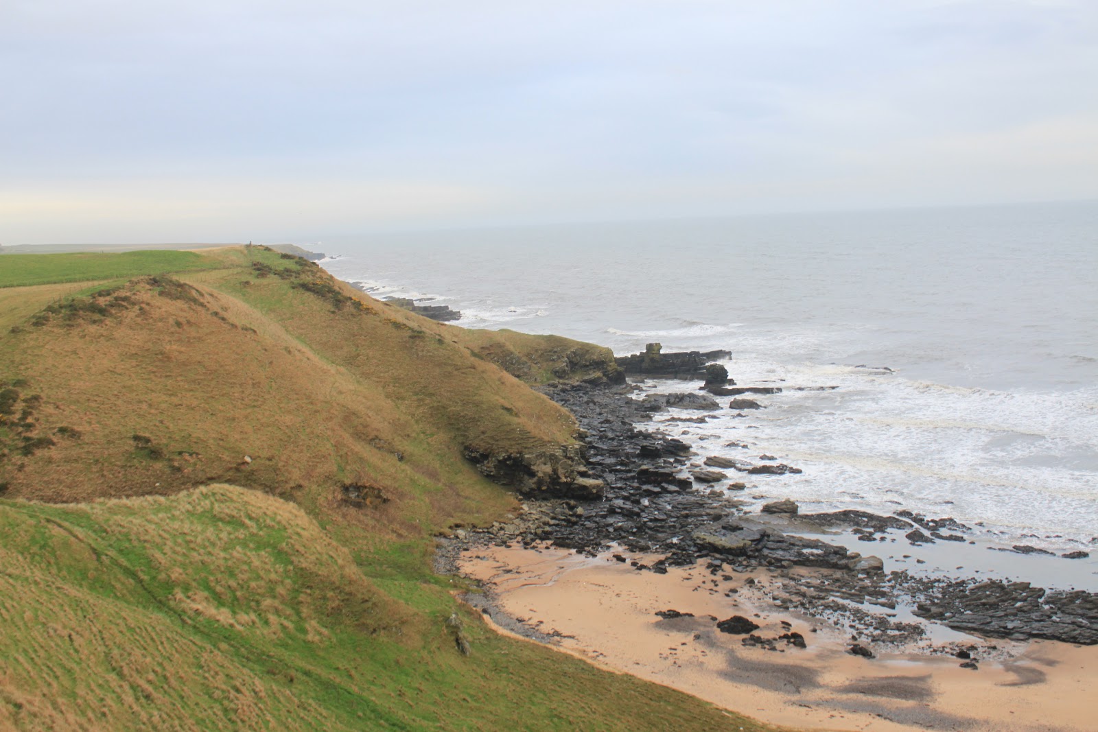
 Looking South to Aberdeen

The cliffs, although quite steep, are grass covered and therefore less intimidating and the path at this point was well trodden. There were no signs through Collieston and we've found that the signs tend to disappear from time to time but since it's a coastal path it doesn't take a genius to work out where to go.

 Collieston Harbour

Collieston is one of these little fishing villages that dot the North East coast and, being on the outer limits of commuting distance of Aberdeen, has remained pretty much unspoilt. Although idyllic to look at I think you would need to be of a certain disposition to want to live here. We made our way around the beach and harbour and past a smaller beach to a view point before picking up the coastal path signs again.

 Looking back to Collieston

 From the viewpoint south

Back to the path

 A wee bit of scrambling and some well built steps took us back up onto the cliff path. Although still breezy the wind was at our backs and with an obvious but not particularly well trodden path it was a pleasant walk. The sea was turbulent with lots of white tops and spray and that led to one or two quite spectacular sights as we passed a few small stony coves.


The path wandered its way along the cliff path sometimes right along the edge, sometimes further back along the edge of the field system. It wasn't long before we got our first sight through the mist and spray of our goal for the day. The forlorn single remaining ruined tower is perched on a headland surrounded by half a dozen or so houses, all that remains of the Slains village that was part of the castle life.

 Looking north to Old Slains

The path offers lots of photo opportunities with rugged coves with lots of crashing waves over the rocks and shallows. We decided that it will be a good walk in the Spring and Summer when the birds will be back nesting on the cliffs.

Forlorn Tower

 Eventually the path drops down onto the access road for the houses and we were able to walk down to the tower itself. The castle was the ancient seat of the Hay family and was destroyed "with gunpowder and cannon fire" in 1594. When the Earl returned from three years in exile, instead of rebuilding the castle be opted to rebuild Bowness castle further north and renamed this castle New Slains. A very informative summary of its history by Andrew Spratt can be found here and I hope he doesn't mind that I've lifted this representation of how the castle may have looked in its heyday.


 There is little left to give any real feel as to what it must have been like and the remaining tower looks decidedly unstable. I'm sure it's safe enough since it's stood for a long time but I'm pretty sure I'd feel a little nervous staying in the surrounding houses during a fierce storm.


The first time we ever visited the castle was to submit a "rephotograph" of the site. This entailed the BBC Landward programme supplying an old photograph and invited the public to go and take an up to date photograph from as near a possible the same spot. My effort for Old Slains can be found here. From the castle site we made our way back up the access road before cutting down to our right to a sandy beach called Broad Haven for lunch. As promised the weather had been getting steadily better and although still breezy it was easy to find a sheltered spot.

 Broad Haven for lunch

From Broad Haven

We decided that rather than retracing our steps we would turn it into a circular walk by heading inland passed the Mains of Slains farm to pick up the tarred road from Cruden Bay to Collieston. This was easy and sheltered walking and we were back at the car around three and half hours after leaving. This wasn't a long walk but hopefully it will get us back into the routine and it was interesting with some great coastal views.

My thanks again to Andrew Spratt for his very informative website.

J
More Photos

Wednesday 19 October 2011

Findlater Castle & Sunnyside Beach

Friday 14th October,

The weather forecast for today was its usual mixture of sunshine and showers, maybe, with light winds except where they would be stronger!! The only constant seemed to be that, if there was going to be any sustained sunshine, it was going to be on the Banff coast. This isn't good for us since we live on the south-side of Aberdeen so the thought of spending the first hour of the journey in traffic is never very appealing. However every time we make the effort we talk about how we need to explore this area more often. Today would be no exception.  Mo had been feeling a bit better this week but we decided on a flat walk rather than risking being half way up a hill only to turn back, so a coastal walk where the sun was predicted to shine seemed like a good idea. We were late leaving the house but at least the traffic had died back a bit and we took a longer, more coastal route via Fraserburgh to Banff and Portsoy. The plan had been to walk from Portsoy to Sandend then on to Findlater Castle and Sunnyside Beach, returning via the waymarked coastal path. However so late were we in getting to Portsoy that we decided that we'd find a cafe for some coffee and start the walk at Sandend, thereby cutting the distance in half.

As promised the weather had improved as we'd journeyed north and, although not yet sunny, it was beginning to make an effort. We parked in the public car park next to Sandend Caravan Park and walked up the unclassified road directly opposite. The road rises quite steeply and gives some good views back down along Sandend beach.


 Looking back to Sandend

After about a mile or so the road flattens out, passing a field full of pigs, and the castle and castle car park is signposted off to the right past a derelict farm complete with dilapidated out building. You can buy it if you like since it had a for sale sign! The grass path now headed towards the sea, passing a Doocot that was associated with the castle. It was restored in 1992 and although you can't actually get in you can see inside and there's also an information board. Amazingly it has some 700 nesting boxes so must have been pretty noisy - and smelly- in its heyday!


 Beehive shaped Doocot

 Around 700 nest boxes

From here it was only a short walk to the view point for the castle. Built sometime in the 16th Century, it must have been an impressive structure and a fantastic piece of engineering for its day. There's little left to see now but the information board at the viewpoint gives a good background to its history and has a picture representation showing the probable layout.


Findlater Castle 

Not much left to see

From the castle viewpoint the route back to Sandend was along the cliffs to the east, but we decided to visit the wonderfully named Sunnyside Beach so headed west, still following the coastal path until skirts a small secluded bay and drops down onto the beach.


 Sunnyside Beach

 Looking west

The path continues along the beach then back up onto the cliffs at the far end but this was the extent of our walk today so we settled down out of the wind and had our lunch. From here we made our way back to the castle viewpoint and followed the waymarked coastal path east towards Sandend. The sun had decided to come out but the wind was still strong and took away any warmth there might have been, but it was pleasant enough with some nice coastal views.


 From the Coastal Path......

...Looking West

The path winds its way along the cliff tops, eventually coming back into Sandend just above the old harbour. Since the walk had been relatively short today we spent some time exploring the village and ate the last of our chocolate sitting out of the wind by the harbour wall. It had been an interesting if very short walk by recent standards. We had left the car around midday, arriving back just before three o'clock.

 Sandend

J
More Photos

Sunday 9 October 2011

Wester Cairn, Mount Battock, Hill of Saughs Circuit

Friday 7th October,

I was on my own today since Mo had been threatening with flu all week so I decided that, after the success of last week, I'd get a bit of height under my boots again this week. Mount Battock is a hill I'd never climbed before but I had photographed it from afar on the many occasions we'd walked in Glen Dye or when we'd climbed Clachnaben, so I felt that today was as good an occasion as any to put that right.

 
Mount Battock from Clachnaben

I was comfortable with the start point at Milden in Glen Esk but when I had a look at the route I intended using on the Walking Highlands website it was pretty apparent that the O&S map was a little bit behind in keeping up with the new estate roads being built, so I took the precaution of printing off a copy and taking it with me. This turned out to be a wise move. The route starts at a small car park on a side road just where the road up Glen Esk crosses the Turret Burn.

Car Park & phone box!

Although it was raining when I set off I was confident that things would improve since the ever reliable forecast was for a "getting better" day. In the meantime however I was in full waterproofs. A little way up the tarred road I passed an old watermill, although the waterwheel there now looks more like a garden feature than anything more practical. After leaving the road and passing the front of Muir cottage, the path breaks out into less cultivated countryside and drops down to cross a feeder stream for Turret Burn.

Old Mill

Easy Crossing

The path follows the Turret Burn now for the next while, climbing steadily but it's easy walking on good well maintained estate roads. When the path forked I checked out the right hand fork where it crossed the burn since this was an alternative route out. The O&S map shows a footbridge but the Walking Highlands description warned that it may not be there and that it would be wise to check the level of the burn. I decided that it was probably crossable with a little effort but that I'd make my mind up nearer the time. The path now veered away from the burn, continuing up at an easy but steady pace onto the flank of a wee hill called Allery. I stopped here for the first time today since the hill brought a bit of relief from the wind that had been increasing in force the higher I got. The views south east down the Glen were hazy under the low cloud but promised to improve as, (or when), the weather improved.

Looking towards Glen Esk

As I cleared the flanks of Allery the wind was straight into my face and the rain, which had been coming through in heavy squalls, felt a bit like hail. It wasn't pleasant and I had a few choice words for the MET office  The upside however was that I was treated to a nice bright rainbow that stayed with me for a while as I trudged ever upwards.

Rainbow

I passed another new path that may have confused me had I not taken precautions and began the first of two steep climbs that would take me up towards Wester Cairn. Walking uphill hurts but I'd argue that it hurts less when you don't need to pick out each step or worry about loose rocks under your feet so the estate track, although unsightly in the big scheme of things, was welcome because I needed all the help I could get. Eventually the path picks up a row of what must be the poshest shooting butts I've ever seen and as I neared the top of this first climb I picked out one of them to shelter in while I had some more juice and chocolate.

Posh Shooting Butt

By now the intervals between the rain showers were getting longer but the strength of the wind seemed to be increasing and was still almost directly into my face until I took a sharp right hand turn to climb up onto Wester Cairn, (717m). The path now changed from estate track to a wide, muddy hill track that made its way up onto the summit, giving the first decent view of Mount Battock.

 
Mount Battock from Wester Craig

From the summit the path dropped downhill for a bit before heading up through an electric fence towards the summit of Mount Battock, (778m). I reached the top in the middle of a torrential squall where the wind was so strong that I don't think any of the rain actually hit the ground. I was not happy!

Nearly there!

Mount Battock trig point

Fortunately there is quite a good shelter cairn at the top so I tucked myself down out of the wind, had my lunch and waited out the squall. Once the rain went off I managed to take some photos but the cloud was too low over Mount Keen to get anything meaningful in that direction.

Mount Keen - honest!!

Towards Clachnaben

Loch Lee in the distance

Now that the sun had finally made an appearance I wandered about the top for a while but the wind only seemed to be getting stronger so it was time to decide on my route back down. I could of course simply head back the way I'd come up but, encouraged by the fact that I could see another estate track at the top of The Hill of Saughs, I decided to try for a different descent. The downside to this was the peat bog that sat between me and the track!

Chosen route down - hopefully!

As luck had it I came across a path heading down towards the bog and I could see what appeared to be the beginnings of a path at the end of the track on the other side. On the way down I flushed then photographed a couple of ptarmagans, which I reckoned meant that I'd made the right choice!

Ptarmagan

The passage through the peat bog was a wee bit of an anti-climax in that it wasn't nearly as wet as I'd expected it to be with all the rain we'd had. I picked up the estate path, (not shown on the O&S map), and it ran parallel with the path I'd used in the way up only now I was a couple of hundred metres higher as I passed over the summit of Hill of Saughs, (656m). With Mount Battock behind me I was now well sheltered from the wind and the long slow descent on the estate track made for pleasant walking.

 
Mount Battock from Hill of Saughs

From left to right - Wester Craig, Mount Battock, Hill of Saughs

A combination of being on the south side of Mount Battock and losing height meant that the wind was becoming less of a chore and I was finally able to take off my waterproofs. The only problem left now was the crossing of the Turret Burn and it did look a bit wider and deeper now that I had to cross it than it did when I had a look on the way up! However being a veteran stepping stone leaper I made short work of it once I'd had a look downstream and found a likely spot.

River crossing

I stopped again for a while to finish off the chocolate and to enjoy the sun before retracing my steps back down past Muir Cottage and the old mill to the car.

I had left the car around half past nine and arrived back around half past three. This was probably between an hour and an hour and a half earlier than I would have been had Mo been with me. There's also the possibility that had she been with me we'd have arrived at the top of Mount Battock in blue skies!!
Ah well never mind it had been a good day out.

J
More Photos

Sunday 2 October 2011

Loch Brandy, the Snub & Green Hill Circuit

Friday 30th September,

We were looking forward to our first Friday walk for a while, especially with the weather forecast telling us that summer had finally arrived, even if it was only for a few days. We decided on Loch Brandy for a couple of reasons. Firstly we had never been there and secondly it was far enough from the coast to escape the fog but not so far west as to get the rain that was coming from that direction. The walk starts in the car park of the Glen Clova Hotel and we were surprised to find it busy. Not only busy with cars but with people milling around or sitting in their cars. They all looked like walkers but they weren't walking anywhere. In the end curiosity got the better of me and I asked the man in the car parked next to us what was going on. He explained that the road up Glen Doll, (and the start of the climb for the two Munros of Driesh and Mayar), was closed for repairs but that they had been told it would be open again shortly. Apparently that had been about an hour earlier! Anyway it didn't affect us so we got kitted up and set off up through the car park to pick up the Public Right of Way to Glen Esk.

We're on our way

The well defined, well maintained path starts uphill immediately, which I always feel is no bad thing although Mo might disagree! We gained height quickly and the views up and down the Glen steadily improved, although there was a haze that didn't do the photographs any favours!

Looking West

Looking South

Looking East

As ever when we go walking these days we generally have a couple of alternatives. Today our first objective was to reach Loch Brandy. The path remained in good condition as we continued to gain height passing the wonderfully named Laird's Chamber.

The Laird's Chamber

The weather was getting steadily warmer as the sun burned off the last of the haze and with the worst of the climb over we enjoyed a pleasant walk for the last half mile or so before we topped a slight rise to catch our first sight of the loch.

Loch Brandy

The path doesn't quite reach the loch shore so getting a good photo was proving a wee bit difficult as we settled down for a well deserved cup of coffee and some chocolate. We found a nice spot just off the path and sheltered from the brisk, but not cold, southerly breeze. We now needed to decide on whether or not we tried for our second goal of the day which was to try for the circuit of the loch and if so in what direction. Going west would mean a short but very sharp climb up onto The Snub. Going east would take us up the less steep but much longer pull onto Green Hill.

Path up to The Snub

In the end Mo made the call and we set off up the steep path towards The Snub. The path here now changed from the well maintained path we'd had all morning to a rougher, broken hill path. The effort involved was quickly rewarded with much improved views of the loch.

Looking across to Green Hill

Higher & Steeper

From the Top

We passed the cairn with a now very stiff breeze at our back and we decided to carry on down the other side before we would stop for lunch. The wind made it an uncomfortable walk along the north side of the loch especially for Mo who struggles in strong winds. We were able to pick out some very hazy views of the distant Lochnagar and Mount Keen. The other hills we could see were unfortunately too vague for me to even take a guess at them. I did however stop on a few occasions to take photographs of The Snub.

Looking back to The Snub

The Snub & Loch

Looking West across the Loch

The wind was becoming a bit of a nuisance by the time we stopped at the cairn that topped Green Hill, (870 metres), but we took what shelter we could and ate our lunch. It was too windy to sit about too long so we headed down the grassy path with the loch now on our right with great views across the loch.

On the way down

We were quite pleased that we'd chosen to head up the steep climb because although the path we were on was nowhere near as steep it was a long slow gradient and would have been a right slog if we'd come this way round. We stopped again at the place we'd had our original coffee break. By now the wind dropped off enough that we were able to have a nice long break before heading on down the original path.

On the way home, looking back

By the time we had arrived back at the car park it was suitably empty so the road up Glen Doll was obviously open and the "baggers" had moved on. We had set off just after ten o'clock and we arrived back just before four o'clock. It had been a good walk and, as ever, it could have been done much quicker but why rush a beautiful day.

J
More Photos