A bit of an explanation needed before I start this post I think. This is a wee bit unusual in that it's not a "long" walk, but I wanted to include it because it's unlikely that we'll ever do Slains Castle under different circumstances. John and Craig are off to Amsterdam for the weekend so Mo and I were drafted to do a bit of dog sitting. There are two dogs, both cocker spaniels and both have more energy than Mo and I put together! The usual routine when we're looking after them is that they get a long walk in the morning and then periodic visits to the back garden in the afternoon for a bit of messing about.
 Freddie & Dougal
The long morning walk today started around half past eleven at the carpark in Cruden Bay on the way down to the harbour where the route starts out along a muddy track through some scrubby looking trees. The path runs alongside then crosses a stream, (can't find a name for it). At the bridge the path splits into three; on the right it leads up onto what, among ourselves, we call the moors; straight ahead which is our return route; and left up a short sharp hill to join a path running alongside a ploughed field.
 Turn left dogs!!
Once up the hill it's only a short distance from there to a farm track that heads up to join the path to Slains Castle. The internet of course is full of stuff on Slains castle, mainly because of its links with Bram Stoker's Dracula. The story goes that Stoker, who used to holiday at the Kilmarnock Arms in Cruden Bay, christened the castle "The Castle of Death" and it became the blueprint for Count Dracula's castle, located somewhere in Transylvania. How much of this is truth and how much is urban myth I honestly don't know, but what I do know is that it's a very impressive structure.
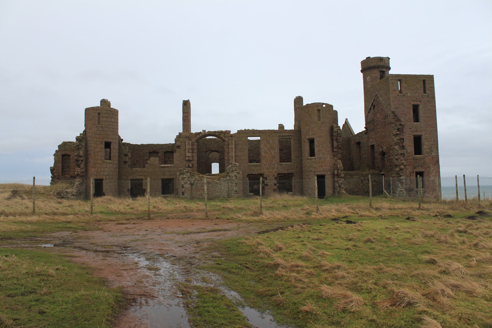 Slains Castle
I've walked round, and photographed, the castle on many occasions and, as you do with lots of old ruins, I always struggled to picture what it must have looked like in its glory days. I was pleased therefore to find a pictorial representation when I was searching through the internet reading up on the history of the place. The biggest surprise was the gardens that appeared to have been laid out on the clifftop, so we had a look at that area today and, although it was difficult to come up with anything positive, it certainly made us look at the area in a different light. To give you an idea of what I'm getting at I've laid out two photos below showing what it looked like in its glory days and, from roughly the same spot, what it looks like today.


The representation of the castle in its glory days came from here and the site contains some good background information on the castle's history.
From the castle we carried on down the path, heading back towards the bridge over the unnamed stream near the start of our walk. About halfway down there's a derelict tower which may or may not be part of the castle buildings, but I have no way of knowing. I guess that any of the buildings in this area will have some connection with the castle.
From the castle we carried on down the path, heading back towards the bridge over the unnamed stream near the start of our walk. About halfway down there's a derelict tower which may or may not be part of the castle buildings, but I have no way of knowing. I guess that any of the buildings in this area will have some connection with the castle.
 Mystery Tower
At the bottom of the hill we recrossed the stream and headed up onto the moors. The area up here is actually overgrown scrub-land that's criss-crossed with paths and motorcycle tracks. It's a great place for the dogs, with lots of open spaces and the occasional gorse bush for them to explore. It also has the great name of Goats Hillock. As well as the scrub and gorse, there's also the remains of what looks like a Second World War military installation. Whether it was an observation post or some other sort of defence area I don't know, but I'm pretty sure that I read somewhere that there was some worry at the time that, if there was to be a seaborne invasion of Britain, then the long sandy beaches at Cruden Bay were a likely spot.
 Old Military Installations
The other thing the moors are good for of course is the view back along the cliffs to the castle. From this position, and especially if the light is right, you can see why Bram Stoker might have been inspired by the Castle of Death!!
 Looking back to Slains
There are also great views of the cliffs and especially so today since it was very windy. We then left the path we would normally follow so that we could pass above the harbour and enjoy the view along a very windswept beach. It's strange how different the shoreline is either side of the Water of Cruden with the cliffs, (the Bullers of Buchan), marching north to Peterhead, while to the south there are sandy beaches all the way to Aberdeen.
 Cruden Bay Harbour & Beach
From here it's an easy walk back through the scrub-land down to the bridge then along the still muddy track to the car. In all the walk takes about an hour and a half but of course it took a little longer than that today because we stopped to take plenty of photos!!
J
Thank you! I enjoyed this post, and the pictures, very much.
ReplyDeleteThis helps me create a mental picture of the area for a book I am reading.
ReplyDeleteJust finished reading the Winter Sea in which this castle plays as the main setting. These pictures are amazing and helped me firm up the images that i had in my head of the castle while reading it! Beautiful!
ReplyDeleteThis comment has been removed by the author.
ReplyDelete