Saturday, 9 July 2011

Glen Tannar & Baudy Meg

Friday 8th July,

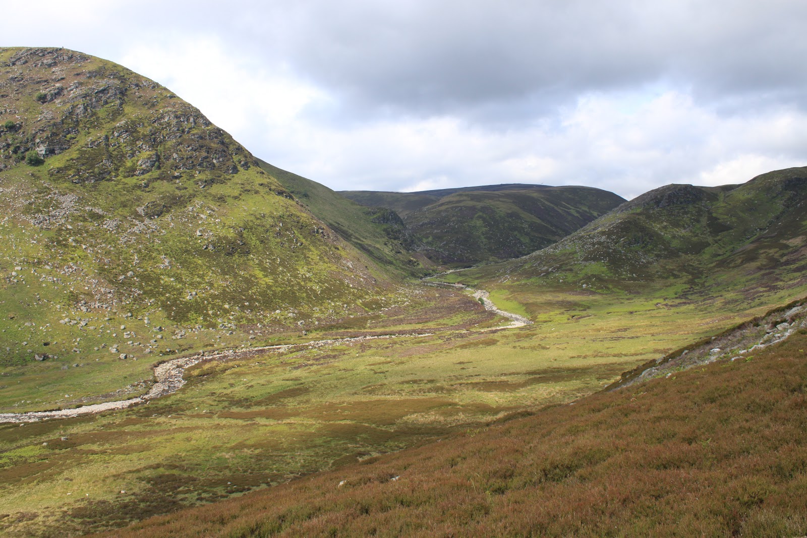
This was one of those days that could only happen in Scotland. The weather forecast on Thursday had promised sunshine and showers with the emphasis definitely on the showers. Sure enough when I got up this morning it was raining pretty hard, so the day looked like a washout before we'd even had breakfast! Never the less we got up and organised, all be it in a slightly more resigned fashion than normal. As it turned out of course by the time we were ready to set off the rain was off and there was even a slight hint of blue in the sky. The forecast even at this stage was mainly heavy showers punctuated with the occasional glimpse of the sun, so choosing where we were going was a challenge. In the end we decided on Glen Tannar, mainly because it gave us options. If it got as wet as suggested we could turn right at the first bridge and do the three bridges; if it stayed a little bit drier we could turn right at the third bridge and go further up the glen and round the side of The Strome then up to join the Firmounth Road; if we were really lucky, and the weather forecasters were wrong, we could even add in the circuit of Baudy Meg. Unlikely as this seemed at the time it was at least a plan that let us make some decisions as we went along.

Even though we were a little bit later in getting there the car park was surprisingly quiet, even for a Friday but we weren't complaining too much! Glen Tannar has been the starting point for a couple of walks since we started this little experiment. The first was way back in January when the snow was thick on the ground and I seemed to spend a fair amount of time on my back side, (read it here); the second was when we climbed Clachan Yell back in April with the now infamous stepping stone crossing!

Another quiet car park

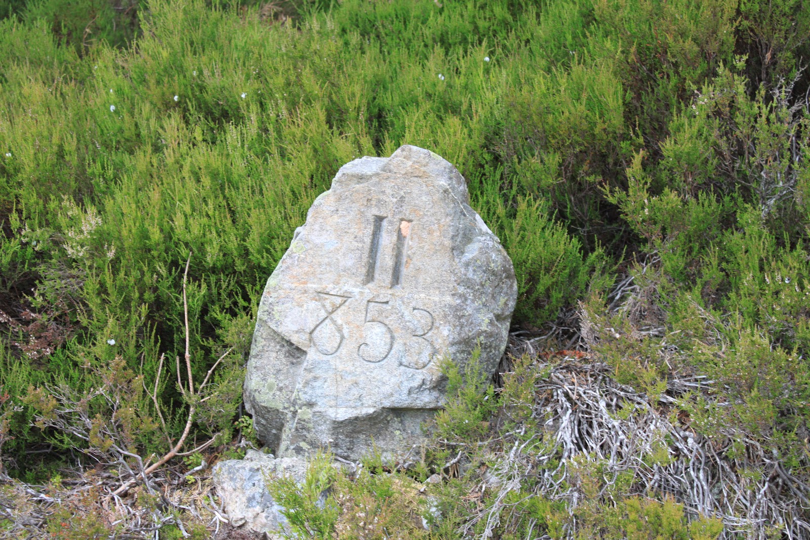
We set off around a quarter to eleven under cloudy skies but we were walking without jackets so it certainly wasn't cold. As usual I took some photos of St Lesmo Chapel and as usual I still can't get the one I want! Someday I might just go and keep taking photos until I stumble blindly onto the perfect shot. Anyway, we crossed the Water of Tannar at the first bridge to pass the private fishing loch and there was still no sign of rain and now the jumpers were coming off! In Glen Tannar there are lots of stones with verses or quotes or strange numbers that don't seem to mean anything in particular. The first of these today is at the apex of a small triangle planted with trees and marked as a memorial to Queen Victoria's Golden Jubilee in, 1887.

 Jubilee memorial

The second was on the right hand side of the path about half way between the loch and the first fishing bothy and is a verse about the trees.

  Carved stones

 As far as we can tell it goes like this:

The pine is the king of the Scottish wood,
And the queen, ah who is she,
The fairest form the forest kens,
The bonny Birken tree.

From here we had a pleasant walk along the river past the first fishing bothy towards Mount Keen but turning left to cross the river at the second bridge of the day. The interesting thing about all of the bridges in Glen Tannar, and there are a lot of them, is how well they're built. Last week when we walked at Loch Callater the bridges were, at best, functional, but the Glen Tannar bridges are solid stone built edifices and it's worth having a look for the key stone and I defy you to identify it without leaning over the parapet so well does it fit.

 Proper bridges!

The walk to the third bridge passes through a high pine forest and it was stuffy and hot, surely it was only a matter of time before the promised rain arrived. Reaching the third bridge meant that we had to decide to carry on along the riverside, (The Water of Allachy at this point), or head back downstream towards the car. By now however we were having serious doubts about the weather forecast so it was an easy decision to carry on up river towards the top of the Glen passing the second fishing bothy.

 Second bothy

From here the path is gently up hill but is easy walking until eventually the path wants to cross a fairly deep ford and carry on up and over Cock Cairn and little Cock Cairn. However about a hundred yards back from the ford there is a branch that leads steeply up to join the Firnmounth Road which joins Glen Tannar to Glen Esk. Turning now back towards the car park the path drops down to cross the little Burn of Skinna at a lochan, (no name), that just happens to be the perfect spot for lunch.

 Lunch stop

We had now reached the point where we had to decide what we should do next. We could follow the Firmounth Road back towards the car, basically retracing our steps but at a higher level, or we could turn off the track and head up and around the slopes of Baudy Meg, (translated as Hill of Hares, and not what you might like it to mean). Again, with no sign of any rain, it was an easy decision to make. Mo was feeling good and although the route was now steadily uphill it wasn't uncomfortably steep and the top held the promise of being above the treeline and maybe even a bit of a breeze.

No idea what this means

Baudy Meg junction
More years ago than I care to remember when I first walked this route, (although in the opposite direction), there was a bothy just where the path breaks out from the trees but it is long gone now and it was even quite difficult to pick out the spot where it had stood.

 Clearing the treeline

The promised breeze when we cleared the trees was very welcome and as we walked along we started playing the favourite game of hillwalkers - name the hills you can see. There are a couple of easy ones of course; Bennachie with its distinctive shape; Carnferg Mon with its large triangular cairn; Gathering Cairn with Mount Keen behind; and Morven with Loch Kinnord in front. There were a couple we'd like to think we got; Broom Hill and Pressendye because of their rounded shape; and in the far distance Tap o Noth, again because of the distinctive shape of the fort at its summit. How many we got right is probably open to debate but it was fun!

Morven
 Gathering Cairn & Mt Keen

The other interesting thing about this part of the walk is the story of the "haunted stag". It's told that one William Cunliffe Brooks had been hunting an elusive stag for a long time but had been unable to get his sights on it long enough to get a shot off. Then, on the 9th of October 1877 he finally managed to bring it down with a shot of 267 feet. In those far off days this was considered a remarkable feat of skill and the gentleman, not known for his modesty, had two memorials erected to himself; one where he stood and one where the poor beast fell. These memorials take the shape of a triangular base with a ball perched on top. Apparently there is a faded inscription that reads "The Haunted Stag. The stag is dead. Sure bullet to its fatal mark hath sped".

 Haunted Stag memorial

Unfortunately the memorials are a fair way off the path and the walk out to them would be over some pretty rough ground, so I contented myself with some photos on a long lens! From here it was an easy flat walk around the flank of Baudy Meg before we started back down a steep rocky path towards the Firmounth Road. On the way down we met up with another couple, Martin and Gail, who were also on the way down and we had a chat about the walks in and around Glen Tannar and played the "name the hills" game yet again. We split up at the Monks Well where our path joined the Firmounth Road and made our way down towards the old view point. About half way down we stopped at the last carved stone of the day, but we were unable to decipher this one.

 No idea what it says

At the view point we decided that rather than carry on straight back to the car, we'd cut down the steep path and pick up the riverside walk so that we could have a look at the old turbine building. Many years ago I'd photographed the old building and had gone looking for where the water had fed into it from the river. At that time I'd been unable to get close enough to the riverbank to find it but in recent years somebody has gone to the trouble of putting up a barbed wire fence around the area where the inlet is so now it's easy to find. Somehow I don't think putting the fence up had the right outcome since now I would imagine anybody walking along the path is going to have a look at what has been fenced off!
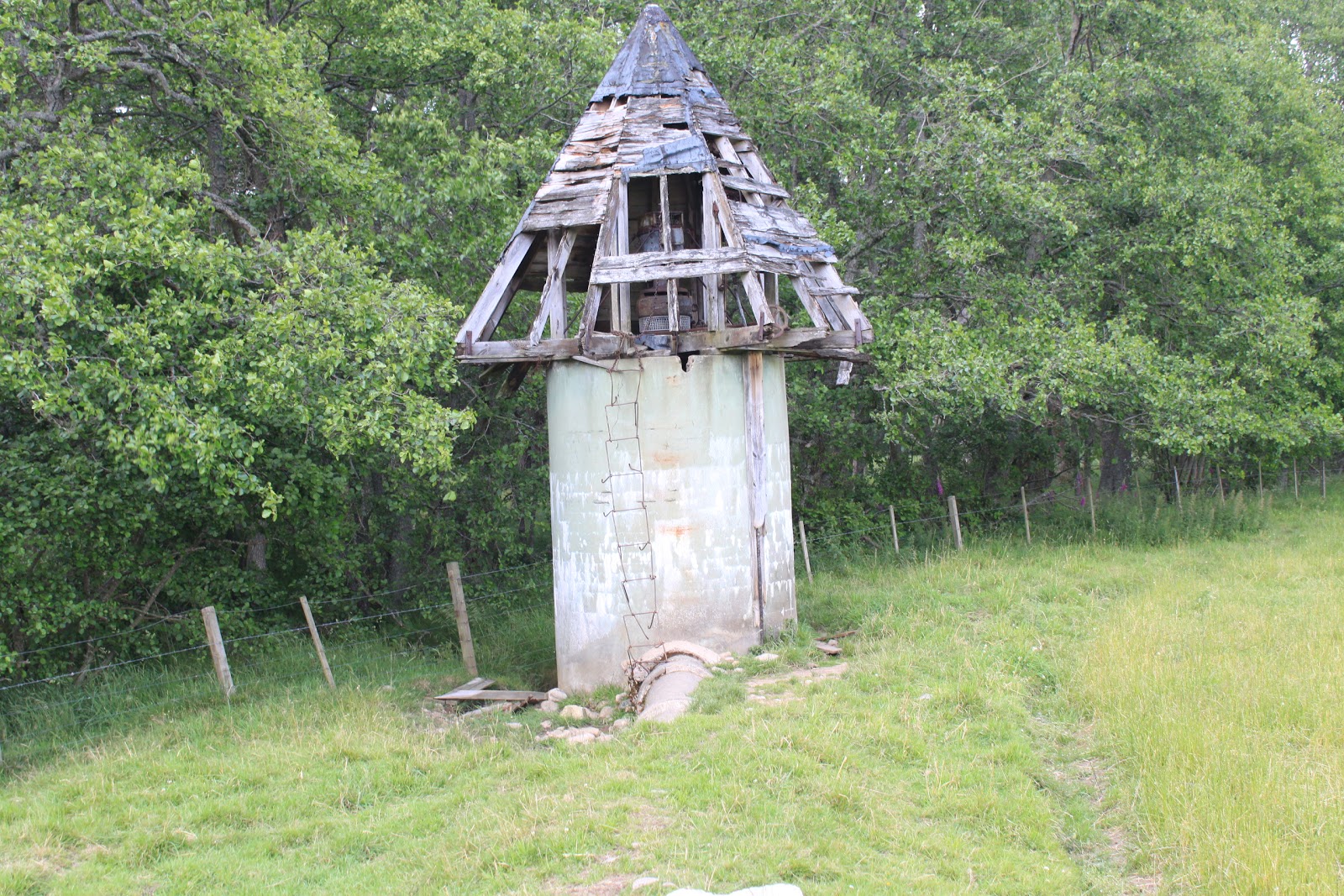
 Turbine house

 Turbine gear

The machinery is still in place although I'm sure anything of any value has long since been stripped away. There used to be an information board by the side of the path but it seems to have been removed. I seem to remember that the turbine supplied electricity to the chapel, but whether that was its sole purpose or not, I can't remember. From here it was only a short walk back to the car park, and there had been no rain whatsoever, so the forecasters don't always get it right! We'd left at a quarter to eleven and were back in the car by half past four. All in all a good day out made more so by the fact that it was unexpected.

As ever my thanks go to Robert Smith's 25 Walks on Deeside book for his information on the "Haunted Stag".

J
More Photos

Saturday, 2 July 2011

Loch Callater Circuit

Friday 1st July,

It's been a couple of weeks since my last post due to a combination of factors - very poor weather, a trip down to Ayrshire to visit Mum and Dad and Mo struggling with a few health problems. However, as ever, we move on. The forecast for the day was cloudy but dry with the promise of some sunny spells and no rain. We decided when we set off that we would stick to a flat walk and were thinking either the Loch Muick circuit or, preferably, Loch Callater since it was relatively new to us. I say relatively because young John and I walked in as far as the lodge back in September 2007 when we were bagging the two Munros that lie between Loch Callater and Loch Muick. However the circuit of the loch was new to Mo and I and, since we had managed an early start, it was Loch Callater that we decided to go for.

The walk starts at a new car park opposite Auchallater farm about a mile south of Braemar on the A93 road towards Glen Shee. The weather on the drive down was pleasant as promised and we parked in the very quiet, but never empty, car park.

 Quiet Car Park

The track into Glen Callater follows the Callater Burn all the way to the loch so there are no navigational problems. The track is in fact the north western end of Jock's Road which passes the lodge and carries on along the east side of the loch then through and over the head of the Glen, eventually exiting into Glen Clova. The "Jock" in Jock's Road comes from John Winter who fought for the right to walk this old drove route in the late nineteenth century when the then new owner of the Glen Doll estate, one Duncan MacPherson, tried to ban all access. The legal action went as far as the House of Lords and led ultimately to the Scottish Rights of Way Act, the most important piece of legislation for walkers until the more recent Land Reform Act in 2005. By the end of the action both MacPherson and the Scottish Rights of Way Society were bankrupt! In recent years we've walked both ends of the road but never the centre section. Maybe we need to rectify that some day!

 Heading up the Glen

The estate track, (Invercauld Estates), makes it very easy walking and the river is particularly nice. The weather was cloudy as predicted but the sunny spells were very warm, which after the last couple of weeks was a welcome change. This nice walk in the sun had one rather strange incident when I was convinced that I could see a pair of eye staring out from a small cave created by a rocky cairn just off the road. It turned out of course to be a trick of the sunlight, but it was very convincing at the time! (The photo maybe doesn't do it justice but you can view a larger version here)

 The Hills have Eyes

It was a much longer walk in than I remembered but no less pleasant for that. Eventually we crossed the burn by an estate bridge and, looking back, had a nice view of Ben Avon with its distinctive granite tors dotted along the ridgeline.

 Ben Avon in the distance

The lodge and bothy at the loch are in a fenced area at the end of the track. The Munro route heads off uphill to the left at this point before turning right to run parallel with the loch for a while, then climbing steadily until it eventually heads into the hills and out of sight. We climbed the low fence to have a look at the lodge, (which was locked up), and the bothy which was maintained by the MBA. We're still not sure we'd ever actually stay in a bothy and this one didn't make us want to change our minds! Don't get me wrong it looked cosy enough and the view is to die for, but I'm just not sure it's our scene.

 The Bothy

 View from the Bothy

We decided that we'd take the anti-clockwise route around the loch. There was no real reason for this other than the fact that there appeared to be no bridge at the far end of the loch and I wanted to be sure that if we had to paddle then the best place was likely to be where the track forded the river. I was pretty sure that even if we had taken the much narrower path and walked clockwise we'd still have found the crossing place but the map was vague on whether the two paths actually met up and there seemed no reason to take the risk. Climbing back out of the fenced area we crossed the Callater Burn again by an Estate bridge passing a little sandy cove that I'm sure would have been a nice picnic spot if this was as far as we had decided to go.

 Picnic spot for another day?

 Loch Callater Lodge & Bothy

The Loch itself is not on the scale of Loch Muick or Loch Lee but it does have some great views as Tolmount and (probably) Cairn Bannoch come into view. The track sticks pretty close to the lochside and we had the company a family of Mallards and what looked like a similar family group of Snipe, although I'm open to correction,

 Snipe - I think!!

The track cuts its way across the marshy head of the loch to a wide shallow ford, no problem for a 4 x 4 but a wee bit more of a problem for us. Fortunately when researching this walk I'd come across a warning from another walker to the effect that the river was easy enough to cross but that it was likely to be deeper than our walking boots. We had come prepared for this by taking our walking sandals with us so we'd have something on our feet when we made the crossing. It turned out that the river was in fact too deep to cross with boots on but the riverbed was soft gravel so we'd probably have been OK with bare feet. Needless to say the water was freezing cold but refreshing never the less!

 River Crossing

We had planned to have lunch at this point but another couple, walking in the clockwise direction, had bagged the best spot so we passed them and stopped at a pleasant grassy mound just off the path. The sun was hot now, (when it showed between the clouds), but the wind had also picked up a little so it was quite refreshing. I'm sure there are worse places to have lunch on a Friday!

 Tolmount is on the left

The path along this side of the loch, (Jock's Road), is much more of a path than the other side but was well maintained with all of the streams feeding into the loch crossed with huge stepping stones so walking was again pretty easy. We stopped for a while on another, larger sandy beach and wondered why it is that some lochs have rugged, rocky banks but some have this fine, sharp sand. I guess there's some geological reason but I'm afraid I don't know what it is.

 Sandy Beach

From here we made our way back to Loch Callater lodge, this time skirting the perimeter and picking up the estate track we'd followed earlier. The walk back was uneventful but we stopped off for a while to sit by the river and take some more photos. There's something very relaxing about sitting by a river on a beautiful day with fantastic views. If nothing else it beats the hell out of working.

 River running

We had left the car park just after ten o'clock and arrived back at three thirty. Again this is a long time and the walk could be done much quicker, but what's the point of that!

J
More photos
For more information on the history of Jock's Road

Saturday, 18 June 2011

Glen Lethnot

Friday 17th June.
On my own today. With Mo feeling a bit under the weather this week she decided that she wasn't quite up for it, especially since this was a new walk so always a bit uncertain about what we might come across. So a bit of a confession to start with; as of about three or four weeks ago I'd never heard of Glen Lethnot, never mind knowing where it was! I'd only come across it while surfing the net looking for challenging, but not killer, walks that would get us out into hills. The Glen nestles between Glen Esk on the north and Glen Clova on the south, (there is a website that will give you more detail if you fancy). Like a lot of the Glens the access is along a narrow single track road that, in this case especially, looked like it needed some serious maintenance! The access road starts just outside the hamlet of Bridgend about five miles from Edzell and is signposted Hunt Hill Lodge. There was a bit of a delay a couple of miles in with a fair sized squad of workmen busy replacing fencing and they obviously weren't expecting some tourist driving in on a Friday morning. The road ends with a car park where another squad of workmen were in the process of building a road bridge over today's river, The Water of Saughs. So much for getting a quiet walk!!

 Car park or building site!

The walk itself started off along good, well maintained estate tracks. There was still some track maintenance going on at the start but, once past the third digger of the day, I finally got the place to myself and never seen another person for the rest of the walk.

 Route into the Glen

The estate road initially follows the Water of Saughs up into the glen until it bears right to head up the side of the Craig of Doune. Although there was no real climbing planned for today this first uphill section made me work a bit, so I guess it was keeping me honest! The walking itself is easy enough with the tracks well drained and smooth. The views, as ever, only got better the higher I got.

 Heading upwards

Eventually the path levels out and I had a very pleasant walk high above the river with great views back down along the glen. The weather was still holding fair, although I knew that the forecast was for it to breakdown later in the day. For the moment however I still had my jacket in my rucksack and was wearing a baseball cap to keep the sun off my bald bit!


 Looking back the way I'd come

There was a bit of confusion by now, and I'd come to the conclusion that either I was on the wrong track, (which I knew I wasn't), or my O&S map was out of date. It was of course the second, which is no real surprise considering that I've had it for the last fifteen years or so! The alternative route to this point was to have left the estate road where it turned up to the right and head straight on towards a zigzag path up to a buttress called West Craig. Where the two paths converged I took a detour along a faint path to the small cairn that marked the top.

 West Craig

Returning to the way I came I carried on along the path high above the river with good views up and down the glen until a junction on the left led me, via another zigzag route, down to the river. While I'd been walking I had been able to look across to the other side and see the path that was to be my route back but, rather worryingly, it seemed to come to a halt half way up the hill. Still even if my map was out of date the chances were the path shown on it would turn up. Initially I had planned to stop at the river for lunch but, being on my own, I was a bit ahead of schedule so decided to get the climb over with first. So after a wee bit of excitement getting across the river as ever I set off up the second and last climb of the day.

 Another river successfully crossed!

Although quite steep, the climb was relatively short, so I was still quite early when I left the track to follow a faint path that led up to quite a substantial cairn on the side of The Shank of Donald Young, (you've got to love the names). There were a couple of things that are worth a mention about this cairn; firstly it's not at the highest point, (this is marked by a much more mundane cairn); and secondly it was built with a brilliantly white stone that looks a bit like granite but probably isn't. It's probably a quartz of some kind but I'm open to suggestions.

Cairn on The Shank of Donald Young

By now the sun had disappeared to be replaced with low, threatening clouds and the wind was picking up, but I was hungry so I sheltered behind the cairn and had a fifteen minute break for lunch. By the time I moved on I could feel the first drops of rain in the wind. I dropped down to pick up the track where I'd left it earlier and carried on, hoping that my worries about it coming to an end were misplaced. I was to be disappointed!

 End of the road - literally!

My out of date map promised me that a path did exist down the side of the Burn of Duskintry, which was only a quarter of a mile or so across some burned back heather, so I set of for a bit of "wild walking". As it happens I picked up a faint path along the edge of the burning and, after one or two false starts, this slowly became an obvious if rather soggy track heading diagonally down towards the burn.

 Ghost of a path!

This turned out to be a pleasant part of the day. I was sheltered from the wind in the valley and although the path was boggy in places, (I don't think we'll do this walk in early spring or autumn), it was easy to follow and easy underfoot. Eventually the valley opens out a little where the burn feeds into the Water of Saughs and although my map had suggested another "interesting" river crossing, I was pleased, and a little surprised, to find an estate footbridge.

 Bottom of the valley

 Estate footbridge

The footbridge was a welcome sight, (the river was quite turbulent at this point and I have a feeling that trying to cross might have been more than interesting), however the bridge was built from timber and wire rope so it was a little bit bouncy! I'm sure that it's perfectly safe but it still made me smile a bit. I also love the notice that says it's for estate people only. I wonder if anybody reads it and decides not to use it and tries to get across the rocks instead. I think not! From the here the path follows the banks of the river until it crosses a small burn where it meets the route to the zigzag climb I mentioned earlier.

 Not quite as sophisticated

From here it was a straightforward walk back to the original estate track towards the car park. By now I was in full waterproofs and the wind was in my face, so not the most enjoyable walk out. The workmen were still there and although I'm sure it's a great place to come to work on a nice day it can't be just as great when the weather turns. As for Glen Lethnot, on the up side it was a nice walk and it's obviously a lot quieter than its neighbours, but on the downside it was almost completely devoid of wildlife. There were a few LBBs and lots of grouse with their chicks, but there were no deer and no "big birds", in fact I saw no raptors at all and only one or two crows. Maybe the workmen put them off.

 Wet end to the day

I had left the car just after half past nine and was back just after two o'clock. Walking on my own means that I walk a little quicker and don't stop as often or for as long so it might be an hour or so longer the next time if Mo comes with me.

J
More Photos

Saturday, 11 June 2011

Edzell, the North Esk and the Rocks of Solitude

Friday 10th June

It was a nice morning when we set off on this walk today. We had decided on a quiet, low-level walk for this week since Mo's health had been a little bit fragile for the last couple of weeks. Edzell is a small town just a few miles west of Brechin and was, for many years the town closest to a major American airbase. Despite this it has remained a largely unspoilt town and always gives the impression of somehow being happily stuck somewhere in the 1950's. It does have one or two claims to fame; there is the Dalhousie Arch at the east entrance to the town; a fantastic town hall in the middle; and a very picturesque church at the western end. For us though the main reason we visit, apart from the general ambience, is that we had a seat put in to commemorate Mo's mum who died in 2006 and who used to "summer" here as a teenager with her family in the years before the second world war.

 Betty's seat


We started the walk at the car park by the church and decided that, although the route is actually in the opposite direction, we would walk the length of the town and pick up the walk further down river. By doing this we were able to photograph the arch and the town hall before we set of on the walk proper. The Dalhousie Arch which straddles the road at the entrance of the town was built in 1899 by the tenants of the Dalhousie Estate in memory of the Count of Dalhousie, John William Ramsey and his wife Lady Ida. There's an interesting piece about their lives here.

 Dalhousie Arch

The first part of walk is along the southern banks of the river North Esk which skirts the edge of the town. Initially the river is wide and flows gently over strange flat rock formations and there's a pedestrian suspension bridge, inevitably called "shakkin brig".

 The North Esk and the Shakkin Brig

At this time of year the well trodden path along the riverbank is lined with trees in full leaf and a multitude of grasses, ferns and wild flowers, none of which we know the names of. However because we knew that this was going to be a walk that was predominately in the woods, we had decided that we would at least make an effort to positively identify some of the trees. So armed with a tree identifier app on my i pod touch we set off.

 River Path

Although the trees and verges are lovely, they do tend to obscure the view of the river, which is a nuisance, but we did come to the conclusion that the majority of the trees lining the path were beech, so that was a start. We met a man who was working for the Angus Salmon Fishing Authority whose job today was to drag dead salmon from the shallows of the river. Apparently the fish were dying because of the low water over the last couple of months and the fact that there had been an increase in the number of fish in the river this year. We asked if it was necessary to get all of the dead fish out of the river because some of them appeared to be in deep water bur he said that it was actually better to leave them in the water but the public complained if they were left. We couldn't work out why people would complain, but there you go!

 Beech Trees - probably!!

The path winds its way along the high steep bank of the river eventually exiting onto the B966 road at the Gannochy Bridge. Turning right, we crossed the river to the north bank and rejoined the walk by going through the blue door into the Burn House estate.

 Through the Blue Door

Burn House is now part of the Goodenough College which is an educational institute based in London supplying accommodation and support for predominately post graduate students from around the world. If you want to read more about their activities you can find it on their website here

The path here stays high above the river with steep banks that channel the ever more turbulent waters through deep narrow gorges. At one point however we were able to make our way down a steep path used by anglers and under a derelict bridge with a statue of a leaping salmon.

 Waterfall with fish ladder on the right

 Leaping Salmon

Also around this area on the walk we came across information boards that told us about the possibility of seeing otters and red squirrels as well as details of the mushrooms and lichens that grow in the area. Well we never saw any otters but we did catch a glimpse of a red squirrel for the second time in three walks. There was no mention of trees though, but by now we were quietly confident that we had seen and could identify Ash, Oak, Sycamore, Silver Birch and Sweet Chestnut as well as the Beech we had seen earlier. We were also pretty sure there were Pine and Larch but they might be open to debate.

 Information Board

There are other "educational" things dotted about like giant wooden toadstools and a carving of a butterfly, (or maybe a moth, I'm not sure).

 Butterfly or Moth?

From here the path makes its way along a quieter river towards the Stones of Solitude, although I'm not entirely certain I could pick them out for you. Somebody told us that we can't miss them because they are huge rocks set in the middle of the river, but having passed lots of huge rocks in the middle of the river, I'm still not sure. Anyway we did eventually come across a horseshoe shaped seat set in a cut out in the cliff and it was here that we stopped for a well deserved lunch.

 Lunch

The only real downside to this walk, apart from so many trees hiding the view, is that the only way back is the way we came. Still it was a pleasant walk and we varied it a little by taking paths further from the river and nearer the Glen Esk road and alongside Burn House.

 Burn House

Once back at the road we retraced the path down the south side of the river. There is a path on the north side that eventually crosses the "shakkin brig" but it's narrow and can be treacherous in wet weather so we decided not to risk it. We cut up a path at that took us out at the west end of the town close to where we had parked the car. We had left at around half past nine and arrived just before three. To be honest it's not a walk that should take as long as this but there is a lot to see with great views - when you get a break in the trees.

J
More Photos

Sunday, 5 June 2011

The Bullers of Buchan from Slains Castle

Sunday 5th June

After a couple of weeks off we finally managed to get a descent walk in, albeit on a Sunday rather than a Friday! We were out on Thursday night then moved over to Cruden Bay to dog and chicken sit for the rest of the weekend. This meant of course that by walking the dogs each day we got plenty of fresh air and exercise but we needed to be careful where we walk them and this is what I find problematical. Anyway after their walk on Sunday morning, (around Slains castle and up onto Goats Hillock ), we decided that, as we were on the north side of the city, it was a good opportunity to take in the Bullers of Buchan. When we first moved over to the east coast from Inverness I must confess we had no idea what the Bullers of Buchan was. In fact the first time we passed the car park we thought it might be a shop! Anyway we've now walked this particular piece of coastline a couple of times. Once from the official car park on the A957 about four miles north of Cruden Bay. The second time we did a loop to the north side of Slains Castle, so this time we decided to link them up and walk from the Slains Castle car park along the coast to the Bullers and carry on north for a while to see what else we could see, (the walk actually goes all the way to Boddam, just south of Peterhead, but we decided that this was just a touch too far for this afternoon).

We set off from the small car park for Slains Castle just north of Cruden Bay. We then ignored the sign for the coastal path to Slains and took the direct track towards the castle.

 Quiet car park

 Towards the castle

Having explored the castle often enough and having written up the castle walk already we stopped short of it and joined the coastal route north at the first of many steep sided bays that give this part of the coast its distinct character, (for the sake of accuracy this one is called "Long Haven"). There is a waymarked post at the start of the path, but it's missing its sign so is less obvious than it might be.

 Who built that wall!!

The path itself is a distinct, well trodden route but it may become a bit overgrown in places at certain times of the year. At this time however there is little to worry about, as long as you remember to watch where you're going and if you're going to look at the thousands, (and I'm not exaggerating), seabirds that have colonised the cliffs then stop and look. Believe me, to try and walk and look at the same time is dangerous! We continued north along this spectacular path until we came to the next couple of bays that cut into cliff side, ("Twa Havens"), before we paused for a look back the way we had come and towards Slains.

 Twa Havens to Slains

The path continues to meander its way along the cliff edge, sometimes within stepping distance of the edge, sometimes more safely 50 yards or so away from the edge. Interestingly when the main path takes the safer route there always seems to be a faint track or two that lead back towards the edge, and as it happens, that's where the better photo opportunities are! Our next goal was the bird infested rock islands of Dunbuy and The Yaud. The number of birds and the noise they made is difficult to describe but it really was quite spectacular. There were a lot of different types of birds, but I'm not knowledgeable to name them all. What I do know is that there were Kittiwakes, Razorbill, Guillemot, Herring Gulls and Shags, (or Cormorants maybe - always difficult to tell from a distance). I'm sure there were other types of gulls but I'm afraid I don't know them well enough.

 Dunbuy

 Razorbill

Dragging ourselves away from the dramas being played out on the cliffs we continued north. I have to say that it was a wrench because it really was the type of thing we could have sat and watched for hours without getting bored! The path continues to make its way north passing yet more bays cut deep into the cliffs with more birds perched on impossible edges and caves that disappear into darkness. The next spectacle comes as we reached the area that gives the area its name. The first point we reached is called "Robie's Haven" and was to give us our real treat of the day. I was busy taking photos of the coast to the north when Mo drew my attention to a couple of birds perched on a cliff around 50 yards or so away. And that was how we came to see our first Puffin in real life! When you consider everything that was going on around us it was a great spot by Mo and one I'm really pleased she made.


 Puffins - fantastic!

 From Robbie's Haven Looking North

From here we made our way down to the small hamlet perched on the cliffs above the Bullers itself. The Bullers is a collapsed cave system, (you can read more about it here ). I'm not too sure about whether or not I'd like to live quite this close to the cliff edge but some of the views and weather conditions you would get would be spectacular.

 The Bullers of Buchan

Officially this should have been the end of our walk for the day, but we decided to carry on a little further because the last time we were here I had managed to get some good photos further up the coast. The path past the Bullers becomes a bit more overgrown and footing would be treacherous in wet weather. Fortunately there was no sign of rain and the weather had been dry all week so with a little care we made our way around to the last "haven" of the day "North Haven".

 North Haven

I guess the only downside of this walk is that the only route back is to retrace your steps. So from here we turned back towards home and got to see all the views from a new perspective! We did of course stop and take more photos of the puffins on the way past!!  Everybody knows that Scotland has spectacular coastlines and cliffs but I wonder sometimes if people realise how close these wonders really are. We had left the car twelve o'clock and arrived back at quarter past three. I'm not suggesting that this is a three hour walk, but we spent a long time watching the birds and taking lots of photos.

J
More Photos