On my own today. With Mo feeling a bit under the weather this week she decided that she wasn't quite up for it, especially since this was a new walk so always a bit uncertain about what we might come across. So a bit of a confession to start with; as of about three or four weeks ago I'd never heard of Glen Lethnot, never mind knowing where it was! I'd only come across it while surfing the net looking for challenging, but not killer, walks that would get us out into hills. The Glen nestles between Glen Esk on the north and Glen Clova on the south, (there is a website that will give you more detail if you fancy). Like a lot of the Glens the access is along a narrow single track road that, in this case especially, looked like it needed some serious maintenance! The access road starts just outside the hamlet of Bridgend about five miles from Edzell and is signposted Hunt Hill Lodge. There was a bit of a delay a couple of miles in with a fair sized squad of workmen busy replacing fencing and they obviously weren't expecting some tourist driving in on a Friday morning. The road ends with a car park where another squad of workmen were in the process of building a road bridge over today's river, The Water of Saughs. So much for getting a quiet walk!!
 Car park or building site!
The walk itself started off along good, well maintained estate tracks. There was still some track maintenance going on at the start but, once past the third digger of the day, I finally got the place to myself and never seen another person for the rest of the walk.
 Route into the Glen
The estate road initially follows the Water of Saughs up into the glen until it bears right to head up the side of the Craig of Doune. Although there was no real climbing planned for today this first uphill section made me work a bit, so I guess it was keeping me honest! The walking itself is easy enough with the tracks well drained and smooth. The views, as ever, only got better the higher I got.
 Heading upwards
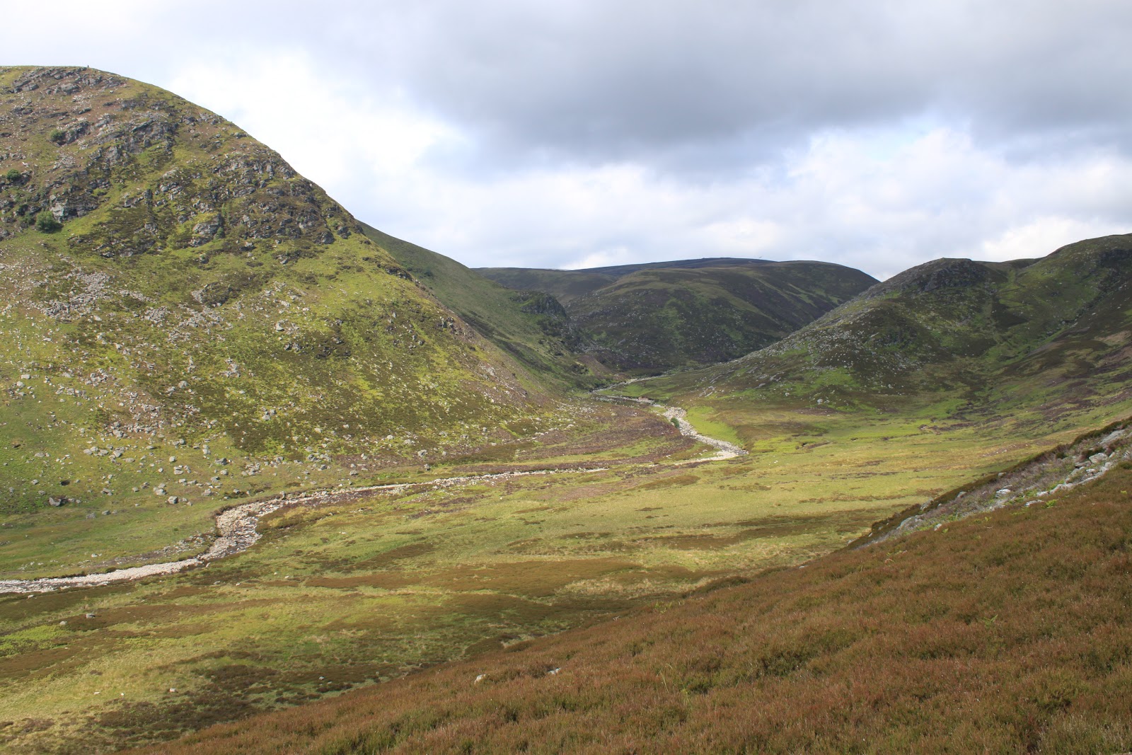
Eventually the path levels out and I had a very pleasant walk high above the river with great views back down along the glen. The weather was still holding fair, although I knew that the forecast was for it to breakdown later in the day. For the moment however I still had my jacket in my rucksack and was wearing a baseball cap to keep the sun off my bald bit!
 Looking back the way I'd come
There was a bit of confusion by now, and I'd come to the conclusion that either I was on the wrong track, (which I knew I wasn't), or my O&S map was out of date. It was of course the second, which is no real surprise considering that I've had it for the last fifteen years or so! The alternative route to this point was to have left the estate road where it turned up to the right and head straight on towards a zigzag path up to a buttress called West Craig. Where the two paths converged I took a detour along a faint path to the small cairn that marked the top.
 West Craig
Returning to the way I came I carried on along the path high above the river with good views up and down the glen until a junction on the left led me, via another zigzag route, down to the river. While I'd been walking I had been able to look across to the other side and see the path that was to be my route back but, rather worryingly, it seemed to come to a halt half way up the hill. Still even if my map was out of date the chances were the path shown on it would turn up. Initially I had planned to stop at the river for lunch but, being on my own, I was a bit ahead of schedule so decided to get the climb over with first. So after a wee bit of excitement getting across the river as ever I set off up the second and last climb of the day.
 Another river successfully crossed!
Although quite steep, the climb was relatively short, so I was still quite early when I left the track to follow a faint path that led up to quite a substantial cairn on the side of The Shank of Donald Young, (you've got to love the names). There were a couple of things that are worth a mention about this cairn; firstly it's not at the highest point, (this is marked by a much more mundane cairn); and secondly it was built with a brilliantly white stone that looks a bit like granite but probably isn't. It's probably a quartz of some kind but I'm open to suggestions.
 Cairn on The Shank of Donald Young
By now the sun had disappeared to be replaced with low, threatening clouds and the wind was picking up, but I was hungry so I sheltered behind the cairn and had a fifteen minute break for lunch. By the time I moved on I could feel the first drops of rain in the wind. I dropped down to pick up the track where I'd left it earlier and carried on, hoping that my worries about it coming to an end were misplaced. I was to be disappointed!
 End of the road - literally!
My out of date map promised me that a path did exist down the side of the Burn of Duskintry, which was only a quarter of a mile or so across some burned back heather, so I set of for a bit of "wild walking". As it happens I picked up a faint path along the edge of the burning and, after one or two false starts, this slowly became an obvious if rather soggy track heading diagonally down towards the burn.
 Ghost of a path!
This turned out to be a pleasant part of the day. I was sheltered from the wind in the valley and although the path was boggy in places, (I don't think we'll do this walk in early spring or autumn), it was easy to follow and easy underfoot. Eventually the valley opens out a little where the burn feeds into the Water of Saughs and although my map had suggested another "interesting" river crossing, I was pleased, and a little surprised, to find an estate footbridge.
 Bottom of the valley
 Estate footbridge
The footbridge was a welcome sight, (the river was quite turbulent at this point and I have a feeling that trying to cross might have been more than interesting), however the bridge was built from timber and wire rope so it was a little bit bouncy! I'm sure that it's perfectly safe but it still made me smile a bit. I also love the notice that says it's for estate people only. I wonder if anybody reads it and decides not to use it and tries to get across the rocks instead. I think not! From the here the path follows the banks of the river until it crosses a small burn where it meets the route to the zigzag climb I mentioned earlier.
 Not quite as sophisticated
From here it was a straightforward walk back to the original estate track towards the car park. By now I was in full waterproofs and the wind was in my face, so not the most enjoyable walk out. The workmen were still there and although I'm sure it's a great place to come to work on a nice day it can't be just as great when the weather turns. As for Glen Lethnot, on the up side it was a nice walk and it's obviously a lot quieter than its neighbours, but on the downside it was almost completely devoid of wildlife. There were a few LBBs and lots of grouse with their chicks, but there were no deer and no "big birds", in fact I saw no raptors at all and only one or two crows. Maybe the workmen put them off.
 Wet end to the day
I had left the car just after half past nine and was back just after two o'clock. Walking on my own means that I walk a little quicker and don't stop as often or for as long so it might be an hour or so longer the next time if Mo comes with me.
J
More Photos
Hi , i enjoyed your walk , there are 2 really good circuits in lethnot Glansie and Monduran , last Monday i did part of the walk you described but i headed straight up in to the glen , the zig zags were on my right , crossed over a two pole bridge and then up until i reached the landrover track,plenty of estate landies driving about, then followed the path down through the zig zags and then back along the path to the car park , there is a lot of deforesting going on just now and the trunks are stacked in the carpark. I did the lethnot to glen esk path yesetrday with a few detours but the views for photos were excellent .
ReplyDelete