After a difficult few weeks it's fine to get back to walking, even if the weather has been, at best, unpredictable. Not that we've been totally idle. At the end of October we had a walk up to Mither Tap from the Bennachie Centre since, despite having lived up here for a long time, it was a walk Mo had never done. It was a fine, if windy, day and I got some good photos so worthwhile. I didn't do a blog since I had blogged a similar walk that included Millstone Hill and the Bennachie tops as well as Mither Tap. We also had a very pleasant walk at Crathes Castle the first weekend in November and although we got some really nice photos it was more a Sunday afternoon stroll on a waymarked trail than a "proper" walk. It was further diluted by the fact that the trail we wanted to take, (the longest in the grounds), was closed for tree felling so maybe when we go back I'll blog that one.
The weather forecast for today was for a dull start but staying as far east as possible would give us the best chance of it staying dry and maybe even see some sunshine later in the day. We decided to fill in one of the gaps in the Scottish Coastal Path that we've been meaning to do for a while. Although we've done bits and pieces of this long distance route during this year, (Inverbervie, Forvie, Slains, The Bullers of Buchan and Findlater Castle to name but a few), there are still a few stretches that are within our reach. This particular walk is signed from the car park at Collieston but we decided to extend it a little by parking at the Forvie Nature Reserve centre and going south a little before turning north along the coast.
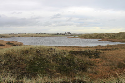
We left the Centre past the new wind turbine that had a detailed justification as to why it had been built and a breakdown of how much it had cast and an estimate of how long it was likely to take to earn back the money. Such is the divisions among those for and against wind turbines. We skirted Sand Loch and picked up the coastal path just south of Collieston.
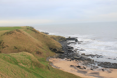
The cliffs, although quite steep, are grass covered and therefore less intimidating and the path at this point was well trodden. There were no signs through Collieston and we've found that the signs tend to disappear from time to time but since it's a coastal path it doesn't take a genius to work out where to go.
Collieston is one of these little fishing villages that dot the North East coast and, being on the outer limits of commuting distance of Aberdeen, has remained pretty much unspoilt. Although idyllic to look at I think you would need to be of a certain disposition to want to live here. We made our way around the beach and harbour and past a smaller beach to a view point before picking up the coastal path signs again.
 Back to the path
A wee bit of scrambling and some well built steps took us back up onto the cliff path. Although still breezy the wind was at our backs and with an obvious but not particularly well trodden path it was a pleasant walk. The sea was turbulent with lots of white tops and spray and that led to one or two quite spectacular sights as we passed a few small stony coves.
The path wandered its way along the cliff path sometimes right along the edge, sometimes further back along the edge of the field system. It wasn't long before we got our first sight through the mist and spray of our goal for the day. The forlorn single remaining ruined tower is perched on a headland surrounded by half a dozen or so houses, all that remains of the Slains village that was part of the castle life.
The path offers lots of photo opportunities with rugged coves with lots of crashing waves over the rocks and shallows. We decided that it will be a good walk in the Spring and Summer when the birds will be back nesting on the cliffs.
Eventually the path drops down onto the access road for the houses and we were able to walk down to the tower itself. The castle was the ancient seat of the Hay family and was destroyed "with gunpowder and cannon fire" in 1594. When the Earl returned from three years in exile, instead of rebuilding the castle be opted to rebuild Bowness castle further north and renamed this castle New Slains. A very informative summary of its history by Andrew Spratt can be found here and I hope he doesn't mind that I've lifted this representation of how the castle may have looked in its heyday.

There is little left to give any real feel as to what it must have been like and the remaining tower looks decidedly unstable. I'm sure it's safe enough since it's stood for a long time but I'm pretty sure I'd feel a little nervous staying in the surrounding houses during a fierce storm.
We decided that rather than retracing our steps we would turn it into a circular walk by heading inland passed the Mains of Slains farm to pick up the tarred road from Cruden Bay to Collieston. This was easy and sheltered walking and we were back at the car around three and half hours after leaving. This wasn't a long walk but hopefully it will get us back into the routine and it was interesting with some great coastal views.
My thanks again to Andrew Spratt for his very informative website.
J
More Photos


What I find hard to comes to terms with, but extremely fascinating as well, is that you can walk along wild and rugged coasts like this, with their quiet villages and peaceful fields, and it’s so easy to assume that it’s always been the same. But a few generations ago armies were rampaging over this land with gunpowder and cannons, blasting houses down and murdering people. And the ruins still stand as testimony. Interesting stuff, John.
ReplyDeleteAlen McF