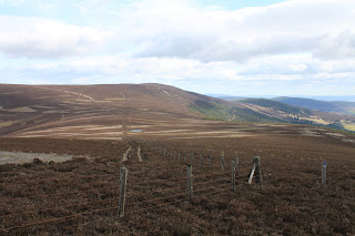
One of the reviewers on the Walking Highlands website, (Walking Highlands), described this as the easiest 9.5k walk in the area. I'm not sure I'd describe it as the easiest, but it is certainly one of the most scenic we've done so far. Pressendye at 620 metres was also to be our first official Graham, (Scottish mountains between 2000 and 2500 feet with at least 500 feet of decent on all sides), so there was a certain amount of anticipation when we set off. The walk is a circular route that starts at the village of Tarland and is waymarked by the MacRobert and Upper Deeside Trusts. This makes navigating easy and although some of the posts were missing their arrows the route was fairly straightforward.
We decided to do the walk in a clockwise direction and I believe this turned out to be a good, albeit random, decision. The first couple of miles is along a minor road so quite hard on the feet but the way was well marked and we started trying to identify the hills we were now looking at. Straight ahead of us was Broomhill, which would be our first top of the day, with a long ridge leading to Pressendye. Looking at it this early in the day it looked a bit intimidating!
As we wandered on, slightly uphill, we were only passed by a couple of cars and the usual postie van so our progress was steady and the weather was glorious. Easily the best day we've had since this little experiment started back in January.
Eventually we ran out of road and made our way onto the right of way to Boultenstone for a while before the waymarks sent us onto the first climb of the day towards a stand of pine trees. Before we tackled the climb we stopped for a cup of coffee and a bit of chocolate, just to boost the sugar levels you understand!
It was very pleasant walking now. The sun was out and, in the shelter of the trees, the wind wasn't a factor. The route was still pretty obvious and after about forty minutes or so we broke out onto the heather clad side of Broomhill quite close to its summit.
The path from here curved its way up onto the long ridge that stretches all the way over the top of Broomhill to the summit of Pressendye. The views from the ridgeline however made us stop for a while and we played spot the hill - well doesn't every hillwalker?
The path along the ridge meandered its way up a steady rise to the unmarked summit of Broomhill (576m), where we got our first proper look at the goal for the day.
The drop down from Broomhill was quite significant but it was on an easy path and the weather was lovely with a stiff breeze at our back to keep us cool. All in all a nice easy walk up to the trig point and the large shelter cairn that marked the top.
We made ourselves comfortable in the cairn, sheltered from the wind, and had a long leisurely lunch. At this point we'd met only one woman who caught up and passed us then turned back to go and look for her husband who was apparently checking the waymark poles and a couple coming towards us who would not even have acknowledged us had we not spoken first. The walk out was steep at first before entering a relatively young forest and easy walking on a grassy path.
The route to this point had been well marked but somewhere on the way down we either missed a marker or the chap behind us who was checking the markers had some work to do! In the end we came out onto the road about three quarters of a mile from Tarland and had to walk along the grass verge until the pavement began. Apart from this little glitch at the end it had been a fantastic day and we rewarded ourselves with ice lollies before we headed home. We had left the car just before 11 o'clock and arrived back, tired but chuffed, at four thirty.
J


No comments:
Post a Comment