Friday 26th August,
Despite the promise to myself last week that I would get some height under my boots this week, circumstances conspired against me. These circumstances meant that Mo and I were in Cruden Bay with the chore of walking the two dogs that belong to our son and his partner. I say chore but that's probably too strong a word since it implies that it's something I don't want to do when in fact it's something that, given a choice, I wouldn't necessarily have chosen to do today. The problem I think is that I'm not, and never have been, a pet person. I simply don't get it. Dogs are dogs; they are animals, a bit cuter than some no doubt, but animals never the less. They are not little people and I dislike intensely the way some owners try to "humanise" them or make out that they are somehow something other than animals. However enough of my prejudices, I know that I'm actually the weirdo and in the minority of about one. There is of course an upside to walking the dogs at Cruden Bay and that is we could walk them on the beach. Not only that but the footbridge across the Water of Cruden, (Ladies Bridge), linking the village of Port Errol to the beach has been refurbished and reopened meaning the beach is accessible again without dodging golf balls!
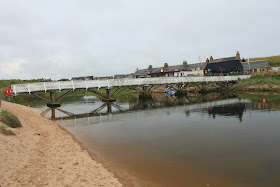
Access Bridge
The tide was well in when we set off making walking in the soft part of the sand a wee bit uncomfortable underfoot. Once we cleared the first bend though we made our way down to the water's edge and it all became a bit easier. I like to think that Cruden Bay, (or Bay of Cruden according to the O&S map), is the last part of the dune system that starts at the mouth of the River Don. But there's a fair gap between the end of the dunes at the Forvie Sands Nature Reserve and the southern end of the bay, so maybe I'm kidding myself on. The beach today was relatively quiet, as you might expect on a Friday, but there were still the occasional dog walkers and at least one family looking for a picnic spot out of the wind. As for taking photos, I decided that I needed to gain some height so I, with the dogs but not Mo in tow, climbed the highest of the dunes to try for some perspective.
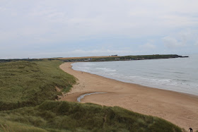
Looking North
Looking South
While I was perched on the top of this sand dune I also took some photographs of Cruden Bay golf course and found myself faced with a crisis of conscience. The problem is that I used to play a bit of golf. Not to any great standard but well enough to enjoy the day out, even if it was only for the walk and the company. In my time of playing I played some very classy courses - St Andrews, (Old and New), Nairn, Lossiemouth, Carnoustie, Ladybank and Downfield to name but a few. But Cruden Bay for me was the best, not necessarily as a test of golf, (although it beat me up every time I played), but as a fabulous place to walk and socialise and occasionally find my ball after hitting it.
Cruden Bay Golf Course
So having extolled the golf course and all its glories why is it that I go into such a rage when I read about an arrogant, egotistical American billionaire with a hair fixation and dubious Scottish ancestry flying in and declaring that he's going to build the "world's best golf course" on what is the Mennie Estate a mere 10miles or so south of where I now stood? Could it be the fawning, crawling, money grabbing business people of Aberdeen who have shown no subtlety at all in their courting of the man? Or maybe it's our elected representatives in Edinburgh who are obviously all for democracy, as long as the great unwashed make the right decision. So when the local planning committee said go away and think again, the Government "called it in". For our own good you understand and just to make sure we got the decision we should have made for ourselves in the first place. Or maybe it's the treatment of the people already living on the estate who, when they refused to sell up and move, were threatened first with compulsory purchase then, when that was withdrawn under massive public pressure, are now being harassed with "landscaping" work going on around their properties. Or maybe it's the fact that the dune system on the Mennie estate is a world class site and is of course protected as a Site of Special Scientific Interest. It seems that the rules protecting such sites are only valid as long as they don't interfere with progress. I'm sure I could make a case for all of these giving me cause to rant, but I think principally it's because it's all a con. Everybody talks about the "best golf course in the world" but nobody talks about the hotel and the 1500 houses, including the four story flats, the carparks and everything else that goes with a leisure complex of this size. It seems though that money talks and the hotel, houses and golf course will happen. But perhaps the greatest irony is that the "best golf course in the world" will not be the best golf course in Scotland and is even unlikely to be the best golf course in Aberdeenshire.
Anyway enough of political ranting and back to our walk along the sands of Cruden Bay. The weather was pleasant with a warm offshore breeze. We spotted a couple of seals who watched us pass and we wondered if they seen us as a threat or if they were just curious about a couple of old dears and their dogs. By the time we reached the end of the bay we had the beach to ourselves apart from a young couple who had passed us earlier. They carried on around the rocky inlet shown on the O&S map as Craig Andrew but we decided that it was time to head back. I understand that this part of the coast had been a prime candidate for a German invasion during the second world war, (hence the derelict listening post on Goats Hillock just south of Slains Castle). There is little left to see apart from concrete blocks lining the beach, some of which appear to form part of a sea wall protecting the golf course. There are however some more obvious signs.
Coastal Defences
From here it was an easy walk back to the car. In all we had been out for a couple of hours and if you're ever in the area and looking for an afternoon stroll I would recommend it.
If you want more information on the Trump housing estate and golf course, and if you have a wee while to spare, I can recommend reading this Report
J
More Photos
A diary of walking in the North East and the Cairngorms of Scotland.
Sunday, 28 August 2011
Saturday, 20 August 2011
In Search of the River Don
Friday 19th August,
I think I should start with a wee bit of an explanation. A couple of years ago my brothers, (one older, one younger), decided that, since we lived in different areas of Scotland we needed a way to keep in touch other than the usual phone calls. So, since we all seemed to like the idea of taking photos, the The Murray Photo Challenge was born. In the couple of years it's been running we've taken turns about at choosing a subject for the month and we need to post a minimum of five photos on that subject. This month it was my turn so for Andrew in Edinburgh it was "An Urban River - The Water of Leith" for Robert in Galston it was "The River of our Childhood - The Burnawn" and for me in Aberdeen it was "Just for a Change - The Don not the Dee". I decided that, as well as taking photos of the Don in and around Aberdeen, it would also be quite good to combine the challenge with this week's walk by trying to get a photo of the source. The problem was that I had no idea where that might be! Still Bing Maps is the font of all such information and with a little patience I followed the river, electronically speaking, from Donmouth, along Strathdon and into the Cairngorms to a point just east of Cock Bridge. Unlike the Dee which starts, rather pretentiously I always felt, some 1200 metres up Braeriach at the Wells of Dee, the first mention of the Don is where two streams, the Allt Veannaich and the Allt Tuileach come together. The only downside appeared to be that it didn't seem very far from the Corgarff Castle car park.
So that's the background as to why I was setting off just before eight on a bright and breezy Friday to try and find the source of the River Don. Sounds a bit like the short version of David Livingstone setting off for Africa to look for the source of the Zambezi! Ironically I started the drive over by going down Deeside as far as Ballater then heading over the military road, (the A939), so I could photograph the old hump-backed bridge over the Gairn at Gairnshiel, something I should have done when we walked in to Corndavon Lodge a couple of weeks ago.
Gairnshiel Bridge
There are some beautiful roads in Scotland, but the part of the A939 between Deeside and Strathdon has to rate up there with the best. After crossing the River Don for the first time today I joined the more notorious part of the A939, the infamous Cock Bridge to Tomintoul stretch, usually closed for most of the winter! No problems like that today though and I parked in the Corgarff Castle car park, feeling slightly guilty at taking advantage without visiting. I salved my conscience by checking the opening times and realised it wasn't open yet anyway.
Corgarff Castle & Car Park
Despite Scotland's "Right to Roam" legislation it's amazing how intimidating a sign reading "private no entry" can still be and that's what confronted me. Still I told myself that it was aimed mainly at cars rather than walkers and boldly set off, feeling more like David Livingstone going off to confront the natives than ever. As it turned out I never met anyone, natives or otherwise for the most of the day.
"Private, No Entry" Aye right!
The walk followed a well maintained tarmac road leading to, according to the map, Delnadamph Lodge. It was quite a strange walk in. On my right the youthful river Don wound its way in tight hairpin bends through lush reeds and grasses, yet on my left I had heather clad hills climbing sharply. I passed what looked like an empty holiday cottage before arriving at Delnadamph Lodge. After Corndavon Lodge I was expecting another grand granite structure so was pretty disappointed with the two storey cottage that I came across. There were a few outbuildings, one of which looked as if it may have been kennels or something similar, but the house was a disappointment.
Delnadamph Lodge
Kennels?
From the lodge I walked past another outbuilding that looked as if it had been refurbished to be a place for people to gather, possibly before setting out for a days shooting. From what I could see looking in the windows there was a large room with tables and chairs and a rudimentary cooking area. There were other rooms but I couldn't see into those. The track I was on would eventually cross the Allt Veannaich so I turned and walked downstream along its banks for a hundred yards or so until it met the Allt Tuileach and the resultant river became the Don.
Veannaich + Tuileach = the Don
It was still early so I decided to follow the Allt Veannaich, being the larger of the two burns, for a while longer so retraced my steps back to the track and carried on. A bridge took the track to the other side and a crossroads. The track to the right led up to another bothy type building, (locked of course), straight on headed out into the hills and left continued to follow the burn, so this was the way I went. After a short walk I was a wee bit surprised to find the burn dammed and a reservoir behind. The Dam wall looked distinctly dodgy but I had a walk across the top of it anyway!
Bridge over the Allt Veannaich
Dam and Resevoir
From the other side
Nice spot!
I carried on for another mile or so, past where the burn split again before the track dropped down to cross the larger of the two then headed up into the high hills. I decided at this point that I'd head back to the locked bothy for lunch and a rest.
Time for Lunch
From here I needed to decide on what to do about getting back to the car. The straightforward way was to retrace my steps but I knew that if I could get across either the Allt Tuileach or the fledgling Don I could pick up the path on the opposite side of the valley and make my way out that way. There was no obvious path between the two sides of the valley, so working on the theory that the Tuileach would be narrower than the Don I made my way along a faint track past a small lochan and a nursery for young grouse then down to the banks of the burn. It became pretty clear that the water was too deep to paddle and only just too wide to jump. However I had decided that I really didn't want to go back the way I'd come so, choosing a part of the bank that was higher on my side than on the other I jumped, landing with one foot in the shallows but managing to stay mainly dry.
Leap of Faith!
Once safely, albeit a little soggy, across the river I made my way up onto the north track and for the first time today came across what looked like the remains of a derelict cottage. After Glen Gairn, where there seemed to be ruins every half mile or so it was a surprise that I hadn't seen any at all on the south side of the river. Was this because of the Lodge and castle being on that side I wondered?
First ruin of the day
The walk out from here was along an estate track past three estate houses that appeared to be still occupied at least some of the time. There had been a fair amount of tree clearing going on and I chatted to one of the JCB drivers collecting the remains of timber and branches into lots and lots of bonfire sized bundles. He explained that although they would normally leave this stuff to rot naturally the estate owners were keen to turn this part of the hill back to heather so the bundles were to be burned. I've got to say that I fancied being around for that spectacle!
Bonfire Bundles
There are times when I walk in the hills and tracks and I come across things that make no sense. I know there will be a perfectly reasonable explanation, but it isn't always obvious. In this case it was a gate. Just an ordinary garden type gate. The problem however was that it was two feet off the ground at the top of the fence. It was tempting to believe that somebody had the drawing upside down but I know there is a proper reason someewhere, there has to be.
Mind the step!
The weather by now was still very pleasant but the clouds were bubbling up so I hurried my way back to the main road stopping only to take a couple of photos of the Briggie Bothy, part of the Allargue Arms Hotel, and the river as it passes under the first of many bridges on its way to Aberdeen. The car park at Corgarff was still empty and I hadn't been clamped, which is always a relief!
Corgarff Castle
I had left the car just after ten o'clock and wandered back around two thirty. It is was an interesting walk and a little different for me. Maybe next week though I'll try to get some height under my boots.
J
More Photos
Sunday, 7 August 2011
Glen Gairn and Corndavon Lodge
Friday 5th August,
After the last few weeks where Glen Gairn had been first reserve, we finally resolved that this would be the week. As it turned out it was also one of the shortest walk in recent weeks! This was due to being a full hour's drive to get there, an hour to get back and a couple of family commitments that meant we were on a relatively tight schedule. The other problem with Glen Gairn is that it's a "there and back" walk, so we simply walk as far as we want, turn and come back. However short as it was it did turn out to be very interesting.
The river which gives the Glen its name is the longest tributary of the River Dee, flowing east for over 30km from its source high on Ben Avon to join the river a mile or so outside Ballater. Our walk started at the rather run down farm of Braenaloin that sits a mile or so beyond the point where the A939 turns to cross the River Gairn on its way to Tomintoul. We parked by the side of the road and as in the past we had the parking space to ourselves. We reckon that we've been in or around this walk three times in the past and had never met anyone. This was going to change today however.
An earlier than usual start, for whatever reason, meant that despite the hour's drive we still managed to be walking by around nine thirty. Despite this we knew that going all the way to Loch Bluig, which is the full walk as I measure it, was going to take too long so we decided that we would go as far as Corndavon Lodge, have lunch then retrace our steps back to the car. We followed the path past the farm, (it's sign posted as the Public Footpath to Tomintoul via Loch Bluig), and swung round past a second farm before joining the estate track that would follow the river all the way to the lodge. For me the Glen is a strange desolate place completely devoid of people. And yet it's a fertile valley and apparently if you know what to look for you can count the remains of 75 separate recognisable dwellings. Of course we don't know what we're looking for but it's pretty obvious that there were a lot of people here at one time and now they've all gone.
One of many ruins
The first building, that's recognisable as such, that comes into sight is what's left of the old manse. It sits perched on the side of the hill and at one time looked over a hamlet by the name of Loinshun. The church itself was at the Bridge of Gairn and the walk from the manse to the church every Sunday must have been a challenge in the winter!
The Manse
There's no navigation required on this walk as the estate track, (Invercauld Estate), is well maintained and runs parallel with the river. More ruins litter the sides of the track, whether these were once dwellings or simply sheep pens it's impossible for us to tell and the next recognisable building is the ruins of Tullochmacarrick Farm on the opposite side of the river. Mo and I once crossed the bridge and walked up to the ruins but it was a sad sight and I sometimes wonder why buildings like this are simply left to rot away. Is it simply down to cost, or is there a reason I'm missing?
Tullochmacarrick Farm
As we walked, the Glen opened up in front of us giving great views of the distant granite tors of Ben Avon. Although the weather was dry with high cloud, there was a stiffish breeze into our faces that, although didn't make walking impossible, it did make it uncomfortable and kept the chat to a minimum.
The Glen opens up
One of the more unusual things about the River Gairn is that it looks so neat and tidy. I know this sounds a bit strange but the thing is there are no raging rapids or deep gulleys or waterfalls, just a gentle river meandering through a mixture of heather and grass. Very peaceful. After about 3km we came to what's left of Daldownie Farm, which has the dubious honour of being the last working farm in the Glen. It was finally demolished in 1977 and local legend has it that the folk there used to come to the door to wave to Queen Victoria as she passed on her many excursions into the hills.
Site of Daldownie Farm
Passing a track coming in from our left, (this leads back to the road and could be made into a circular walk but would mean a walk of around a mile and a half along the road to get back to the car), we continued along the track, crossing the narrow but fast flowing Duchrie Burn by a small wooden bridge. Further on however we crossed the Gairn by a full sized, pretty impressive, iron bridge. The story is told that the bridge was actually built to form part of the railway extension that would join Braemar and Ballater. Queen Victoria however was not impressed and felt that such an extension would pass too close to Balmoral so the extension was never built. The bridge then was surplus to requirements and ended up here in Glen Gairn. The thing about the bridge to look at is that it really couldn't be anything other than a railway bridge!
Solid Victorian Construction
The track now continues along the other side of the river, passing what is left of a proposed mill project which never came to fruition. I must confess at this point that if this hadn't been pointed out to me by a note in our guide book I would never have picked it out as such. From this point our destination of Corndavon Lodge comes into view.
Corndavon Lodge
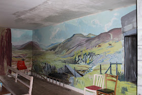
Built as a a shooting lodge, there is very little left of what must have been an impressive granite building. It was built by Lord Cardigan of Crimean fame and was owned, by among others, King George VI before it was destroyed by fire. Having been here before, we knew that the walls inside the building had painted murals showing the surrounding countryside, but my best efforts to photograph them through the steel grilles were pretty fruitless. There's a second, smaller building that once housed the staff but in later years was a bothy of some standing. However it was closed up in the 1990's due to vandalism and we've lost a great place for rest due to the thoughtless antics of a few morons.
What's left of the Lodge
Bothy
We had just settled down in the shelter of the bothy for our lunch, when we were surprised by the arrival of a 4x4 minibus full of tourists. They had come from the direction of Loch Bluig and were in the care of Braemar Highland Safaris. They pulled up by the lodge and we were a wee bit jealous of them because their excursion obviously included a look inside the lodge, which meant that they would get the photographs I had wanted! However I had not reckoned on Mo's determination to have a look because as we were passing the lodge on our way back the guide, (in full Highland Dress of course), was just locking up. "Any chance of a look inside?" says the bold Maureen, "It's just that we'd like to get photos of the murals". Now to be fair the man would have been perfectly within his rights to point out that his group had paid good money to see them and that if we were that keen then we could take the tour. However he was a perfect gentleman and gladly showed us around and gave us a brief history of the buildings and their murals.
Main Wall
Side Wall
Alcove
The murals were originally painted in 1968 by Major Philip Erskine. The story goes that he was attending a dinner hosted by Queen Elisabeth the Queen Mother who, when she heard that he enjoyed painting murals, asked him to paint one for her. Then in 1998 the vandals mentioned earlier destroyed the original and the company who maintained the building was forced to replaster the walls. However when the now retired Philip Erskine was made aware of the vandalism at his home in South Africa, he promptly returned to Scotland to restore and extend the paintings. So after many thanks to the guide, (goes to show that you shouldn't make snap judgements about people you meet when you're out and about), we set off back the way we had come. Apart from the tourist bus passing us and a Landrover with a couple of lads who looked as if they were working, we didn't meet anyone - again. It seems such a waste that a beautiful area doesn't see more walkers, not that we were complaining too much.
We were back at the car around 2 o'clock and, since we were earlier than we had anticipated, we headed over the hills to Braemar because this road gives great views of Lochnagar.
Lochnagar
All in all it turned out to be an interesting, if not very long, day and if we had decided to go on to Loch Bluig we would never have had a chance to go into the Lodge so all's well that ends well.
My thanks go again to Robert Smith and his highly informative 25 Walks on Deeside as well as the nameless guide from Braemar Highland Safaris who kindly interrupted his tour to give us a brief history of the Lodge and the murals.
J
More Photos
After the last few weeks where Glen Gairn had been first reserve, we finally resolved that this would be the week. As it turned out it was also one of the shortest walk in recent weeks! This was due to being a full hour's drive to get there, an hour to get back and a couple of family commitments that meant we were on a relatively tight schedule. The other problem with Glen Gairn is that it's a "there and back" walk, so we simply walk as far as we want, turn and come back. However short as it was it did turn out to be very interesting.
The river which gives the Glen its name is the longest tributary of the River Dee, flowing east for over 30km from its source high on Ben Avon to join the river a mile or so outside Ballater. Our walk started at the rather run down farm of Braenaloin that sits a mile or so beyond the point where the A939 turns to cross the River Gairn on its way to Tomintoul. We parked by the side of the road and as in the past we had the parking space to ourselves. We reckon that we've been in or around this walk three times in the past and had never met anyone. This was going to change today however.
An earlier than usual start, for whatever reason, meant that despite the hour's drive we still managed to be walking by around nine thirty. Despite this we knew that going all the way to Loch Bluig, which is the full walk as I measure it, was going to take too long so we decided that we would go as far as Corndavon Lodge, have lunch then retrace our steps back to the car. We followed the path past the farm, (it's sign posted as the Public Footpath to Tomintoul via Loch Bluig), and swung round past a second farm before joining the estate track that would follow the river all the way to the lodge. For me the Glen is a strange desolate place completely devoid of people. And yet it's a fertile valley and apparently if you know what to look for you can count the remains of 75 separate recognisable dwellings. Of course we don't know what we're looking for but it's pretty obvious that there were a lot of people here at one time and now they've all gone.
One of many ruins
The first building, that's recognisable as such, that comes into sight is what's left of the old manse. It sits perched on the side of the hill and at one time looked over a hamlet by the name of Loinshun. The church itself was at the Bridge of Gairn and the walk from the manse to the church every Sunday must have been a challenge in the winter!
The Manse
There's no navigation required on this walk as the estate track, (Invercauld Estate), is well maintained and runs parallel with the river. More ruins litter the sides of the track, whether these were once dwellings or simply sheep pens it's impossible for us to tell and the next recognisable building is the ruins of Tullochmacarrick Farm on the opposite side of the river. Mo and I once crossed the bridge and walked up to the ruins but it was a sad sight and I sometimes wonder why buildings like this are simply left to rot away. Is it simply down to cost, or is there a reason I'm missing?
Tullochmacarrick Farm
As we walked, the Glen opened up in front of us giving great views of the distant granite tors of Ben Avon. Although the weather was dry with high cloud, there was a stiffish breeze into our faces that, although didn't make walking impossible, it did make it uncomfortable and kept the chat to a minimum.
The Glen opens up
One of the more unusual things about the River Gairn is that it looks so neat and tidy. I know this sounds a bit strange but the thing is there are no raging rapids or deep gulleys or waterfalls, just a gentle river meandering through a mixture of heather and grass. Very peaceful. After about 3km we came to what's left of Daldownie Farm, which has the dubious honour of being the last working farm in the Glen. It was finally demolished in 1977 and local legend has it that the folk there used to come to the door to wave to Queen Victoria as she passed on her many excursions into the hills.
Site of Daldownie Farm
Passing a track coming in from our left, (this leads back to the road and could be made into a circular walk but would mean a walk of around a mile and a half along the road to get back to the car), we continued along the track, crossing the narrow but fast flowing Duchrie Burn by a small wooden bridge. Further on however we crossed the Gairn by a full sized, pretty impressive, iron bridge. The story is told that the bridge was actually built to form part of the railway extension that would join Braemar and Ballater. Queen Victoria however was not impressed and felt that such an extension would pass too close to Balmoral so the extension was never built. The bridge then was surplus to requirements and ended up here in Glen Gairn. The thing about the bridge to look at is that it really couldn't be anything other than a railway bridge!
The track now continues along the other side of the river, passing what is left of a proposed mill project which never came to fruition. I must confess at this point that if this hadn't been pointed out to me by a note in our guide book I would never have picked it out as such. From this point our destination of Corndavon Lodge comes into view.
Corndavon Lodge
Built as a a shooting lodge, there is very little left of what must have been an impressive granite building. It was built by Lord Cardigan of Crimean fame and was owned, by among others, King George VI before it was destroyed by fire. Having been here before, we knew that the walls inside the building had painted murals showing the surrounding countryside, but my best efforts to photograph them through the steel grilles were pretty fruitless. There's a second, smaller building that once housed the staff but in later years was a bothy of some standing. However it was closed up in the 1990's due to vandalism and we've lost a great place for rest due to the thoughtless antics of a few morons.
What's left of the Lodge
Bothy
We had just settled down in the shelter of the bothy for our lunch, when we were surprised by the arrival of a 4x4 minibus full of tourists. They had come from the direction of Loch Bluig and were in the care of Braemar Highland Safaris. They pulled up by the lodge and we were a wee bit jealous of them because their excursion obviously included a look inside the lodge, which meant that they would get the photographs I had wanted! However I had not reckoned on Mo's determination to have a look because as we were passing the lodge on our way back the guide, (in full Highland Dress of course), was just locking up. "Any chance of a look inside?" says the bold Maureen, "It's just that we'd like to get photos of the murals". Now to be fair the man would have been perfectly within his rights to point out that his group had paid good money to see them and that if we were that keen then we could take the tour. However he was a perfect gentleman and gladly showed us around and gave us a brief history of the buildings and their murals.
Main Wall
Side Wall
Alcove
The murals were originally painted in 1968 by Major Philip Erskine. The story goes that he was attending a dinner hosted by Queen Elisabeth the Queen Mother who, when she heard that he enjoyed painting murals, asked him to paint one for her. Then in 1998 the vandals mentioned earlier destroyed the original and the company who maintained the building was forced to replaster the walls. However when the now retired Philip Erskine was made aware of the vandalism at his home in South Africa, he promptly returned to Scotland to restore and extend the paintings. So after many thanks to the guide, (goes to show that you shouldn't make snap judgements about people you meet when you're out and about), we set off back the way we had come. Apart from the tourist bus passing us and a Landrover with a couple of lads who looked as if they were working, we didn't meet anyone - again. It seems such a waste that a beautiful area doesn't see more walkers, not that we were complaining too much.
We were back at the car around 2 o'clock and, since we were earlier than we had anticipated, we headed over the hills to Braemar because this road gives great views of Lochnagar.
Lochnagar
All in all it turned out to be an interesting, if not very long, day and if we had decided to go on to Loch Bluig we would never have had a chance to go into the Lodge so all's well that ends well.
My thanks go again to Robert Smith and his highly informative 25 Walks on Deeside as well as the nameless guide from Braemar Highland Safaris who kindly interrupted his tour to give us a brief history of the Lodge and the murals.
J
More Photos
Monday, 1 August 2011
Glen Dye & Corr Bothy Circuit
Saturday 30th July
We moved our walk this week from Friday to Saturday for a couple of reasons. Firstly the weather forecast was more hopeful for the Saturday and secondly I wanted to break the back of getting the spare room decorated! For the last couple of weeks Glen Gairn has been one of the alternatives and this week was no exception. However despite being the favourite, and our normal rule of never changing the plan, we were put off by the thought of an hour and a half sitting in the car to get there. The alternative we chose in the end was Glen Dye, despite our visit there in January, (you can read it here), when we included Clachnaben. This time we decided that we would walk further into the Glen then make it up from there!
We parked in our usual spot about a mile or so past the Clachnaben car park on the B975 road over the Cairn 'o Mount and set off around 9.45. The day was a little overcast but quite warm so the jackets were put through the rucksacks 'just in case.' The only people we saw at the start were two elderly men who set off not far behind us.
First bridge of the day
As always we took our time and had a good look round as we find that no matter how many times we visit there's always something else to see. A good example of this were the reed beds which were so green and lush it's difficult to accept that we've never noticed them before. They've probably always been there and either we didn't notice or were there at a different time of year.
We decided to make our way out as far as the Corr Bothy to have our coffee. We saw quite a variety of birdlife in the first part of the walk, some of which we hoped to identify at a later date! As we always do when we walk here we took a short detour to a weir that we think is part of the raw water reservoir. The reason we take this detour is that when we first visited the weir many years ago, we saw an otter about ten seconds before it saw us - not quite sure who was more surprised! No luck this time though, but still worth the look. We were also delighted to see a live frog as we'd passed a few dried out carcases of ones that had come to a sad end! We also saw a fair number of large dragonflies in a petrol blue colour, but they never sit long enough to be able to photograph them.
Stonechat(?)
We finally reached the bothy but, since it was now lovely and sunny, we decided to have our coffee outside, so turned left towards the river, (the Water of Dye), and, crossing the bridge settled on the bank for fifteen minutes or so. The men who had been following behind us sauntered along the path as we were having our break and we had a chat with them before we left. They were telling us that they looked after the bothy on behalf of the Mountain Bothy Association, (MBA), and gave us an idea of what had been done over the last few months. As always it looks great and we owe them a debt of gratitude for their hard work and dedication.
After coffee it was time to decide if we would walk on or go back the way we'd come, but take the high road instead of the low one to make the walk longer. But as we both felt up for it, we decided to crack on. So we went back to the bothy and turned left, continuing to follow the path up river, (the path eventually goes as far as Glen Esk, not that we would be going that far today). The path here was good underfoot and generally flat so the walking was easy and it gave us time to think about the people who must have populated the Glen in days gone by. It was good fun looking out for what we took to be the remains of cottages or fields or enclosures and trying to imagine how it all came together. An almost impossible task without the help of Tony Robinson and his Time Team colleagues. By now the sun was beating down and the glen was truly beautiful. We had a great view of Mount Battock which was the prominent hill at this point. Hopefully a walk for another day, either from here or maybe from Glen Esk.
We enjoyed a pleasant walk towards the head of the glen still following the lovely Water of Dye as it got steadily narrower and narrower. We were heading for a small hut that looks as if it acts as a sheep shelter, where we'd decided to have our lunch. All along the Glen there were estate bridges some of which were in a poor state and we were glad we didn't need to cross the river at any point! We're always amazed at how some of the trees manage to survive when they're so exposed to all the elements. We came across a lone Silver Birch. It looked as if the tree had fallen over at some point and this lovely tree had literally "branched out" from the side.
As our lunch spot got closer we began to look forward to a wee rest and some sustenance, but first we had to negotiate a bridge over a tributary of the Water of Dye with the intriguing name of The Burn of Badymicks. We decided it was safer to cross one at a time! We had a lovely view from the hut and were happy to while away half an hour or so just taking it all in.
Our route now left the Water of Dye to follow the Burn of Badymicks uphill along a path that has been recently upgraded, but upgraded or not it was still uphill! The slog however was broken up by the odd unusual view - there's still a lot of work going on with these paths and the first piece of machinery we came across was an 8 wheeled buggy, (that's the technical term of course), which I think we might have borrowed had the keys had been in it.
There was plenty of more natural things to look at as well - John particularly liked the pond-skaters!
It was a steady rather than steep pull up and when we got towards the top of the climb we had a nosy at the new shooting butts that are now in place, complete with steps made from pallets - it was very impressive even though I couldn't see over the top being a shorty! This of course is what the building work and path upgrading is all about. I guess the estate needs to pay for itself in some way.
As we neared the top of the Hill of Badymicks, (575m), we met a couple who were coming down our path and they seemed to be heading for Mount Battock. I can only hope they got a view because when we looked back, the top was shrouded in mist.
Mount Battock in the Mist
Our route now took us over a long high plateau towards the distant Clachnaben. There was evidence of more path work going on here and I'm sure that by the time we come back here it will seem less like a wilderness. The landscape has a strange alien feel to it and we chatted about how to describe it and decided that perhaps "lunar" was the best we could come up with. The whole area is very flat with either dark brown peat bogs or very light, almost white, gravel with weather worn mounds of heather that stand like some grotesque parodies of mushrooms. It's very weird and we decided that it would make a good location for an episode of Dr Who!
Lunar Landscapes
As we headed towards Clachnaben we remembered to stop and play the usual game of "name the hills we can see" - among them Clachnaben of course, Morven, Pressendye and Bennachie all a bit hazy but we were sure we were right - not!
Towards Clachnaben
Apart from the couple on their way to Mount Battock, we had met nobody since leaving the two old boys at the bothy, but when we reached the top of the Hill of Edendocher, (577m), and the junction in the path to Clachnaben, we could see at least half a dozen people up on the tall granite tor. So if we'd had any second thoughts about going across they were quickly dashed. Instead we headed down hill, past yet more machinery including a road roller complete with keys, stopping off at the Cairn of Finglenny to take in the view back up to Clachnaben.
Cairn of Finglenny
From here it was an easy downhill walk, (well with a wee bit of undulation), back to the Corr Bothy where we settled down on the little wall at the front of the building and polished off the last of the juice and chocolate. We had considered taking the alternative, and slightly longer, high road out of the Glen but we were pleased with what we had achieved today so simply retraced our steps back to the car. We had left around nine forty-five and arrived back, sun burned and happy, about half past four.
Mo
More Photos
We moved our walk this week from Friday to Saturday for a couple of reasons. Firstly the weather forecast was more hopeful for the Saturday and secondly I wanted to break the back of getting the spare room decorated! For the last couple of weeks Glen Gairn has been one of the alternatives and this week was no exception. However despite being the favourite, and our normal rule of never changing the plan, we were put off by the thought of an hour and a half sitting in the car to get there. The alternative we chose in the end was Glen Dye, despite our visit there in January, (you can read it here), when we included Clachnaben. This time we decided that we would walk further into the Glen then make it up from there!
We parked in our usual spot about a mile or so past the Clachnaben car park on the B975 road over the Cairn 'o Mount and set off around 9.45. The day was a little overcast but quite warm so the jackets were put through the rucksacks 'just in case.' The only people we saw at the start were two elderly men who set off not far behind us.
First bridge of the day
As always we took our time and had a good look round as we find that no matter how many times we visit there's always something else to see. A good example of this were the reed beds which were so green and lush it's difficult to accept that we've never noticed them before. They've probably always been there and either we didn't notice or were there at a different time of year.
Reed Beds
We decided to make our way out as far as the Corr Bothy to have our coffee. We saw quite a variety of birdlife in the first part of the walk, some of which we hoped to identify at a later date! As we always do when we walk here we took a short detour to a weir that we think is part of the raw water reservoir. The reason we take this detour is that when we first visited the weir many years ago, we saw an otter about ten seconds before it saw us - not quite sure who was more surprised! No luck this time though, but still worth the look. We were also delighted to see a live frog as we'd passed a few dried out carcases of ones that had come to a sad end! We also saw a fair number of large dragonflies in a petrol blue colour, but they never sit long enough to be able to photograph them.
Stonechat(?)
Wheatear (?)
We finally reached the bothy but, since it was now lovely and sunny, we decided to have our coffee outside, so turned left towards the river, (the Water of Dye), and, crossing the bridge settled on the bank for fifteen minutes or so. The men who had been following behind us sauntered along the path as we were having our break and we had a chat with them before we left. They were telling us that they looked after the bothy on behalf of the Mountain Bothy Association, (MBA), and gave us an idea of what had been done over the last few months. As always it looks great and we owe them a debt of gratitude for their hard work and dedication.
Corr Bothy
After coffee it was time to decide if we would walk on or go back the way we'd come, but take the high road instead of the low one to make the walk longer. But as we both felt up for it, we decided to crack on. So we went back to the bothy and turned left, continuing to follow the path up river, (the path eventually goes as far as Glen Esk, not that we would be going that far today). The path here was good underfoot and generally flat so the walking was easy and it gave us time to think about the people who must have populated the Glen in days gone by. It was good fun looking out for what we took to be the remains of cottages or fields or enclosures and trying to imagine how it all came together. An almost impossible task without the help of Tony Robinson and his Time Team colleagues. By now the sun was beating down and the glen was truly beautiful. We had a great view of Mount Battock which was the prominent hill at this point. Hopefully a walk for another day, either from here or maybe from Glen Esk.
We enjoyed a pleasant walk towards the head of the glen still following the lovely Water of Dye as it got steadily narrower and narrower. We were heading for a small hut that looks as if it acts as a sheep shelter, where we'd decided to have our lunch. All along the Glen there were estate bridges some of which were in a poor state and we were glad we didn't need to cross the river at any point! We're always amazed at how some of the trees manage to survive when they're so exposed to all the elements. We came across a lone Silver Birch. It looked as if the tree had fallen over at some point and this lovely tree had literally "branched out" from the side.
Silver Birch
As our lunch spot got closer we began to look forward to a wee rest and some sustenance, but first we had to negotiate a bridge over a tributary of the Water of Dye with the intriguing name of The Burn of Badymicks. We decided it was safer to cross one at a time! We had a lovely view from the hut and were happy to while away half an hour or so just taking it all in.
Our route now left the Water of Dye to follow the Burn of Badymicks uphill along a path that has been recently upgraded, but upgraded or not it was still uphill! The slog however was broken up by the odd unusual view - there's still a lot of work going on with these paths and the first piece of machinery we came across was an 8 wheeled buggy, (that's the technical term of course), which I think we might have borrowed had the keys had been in it.
There was plenty of more natural things to look at as well - John particularly liked the pond-skaters!
Pond Skaters
It was a steady rather than steep pull up and when we got towards the top of the climb we had a nosy at the new shooting butts that are now in place, complete with steps made from pallets - it was very impressive even though I couldn't see over the top being a shorty! This of course is what the building work and path upgrading is all about. I guess the estate needs to pay for itself in some way.
As we neared the top of the Hill of Badymicks, (575m), we met a couple who were coming down our path and they seemed to be heading for Mount Battock. I can only hope they got a view because when we looked back, the top was shrouded in mist.
Mount Battock in the Mist
Our route now took us over a long high plateau towards the distant Clachnaben. There was evidence of more path work going on here and I'm sure that by the time we come back here it will seem less like a wilderness. The landscape has a strange alien feel to it and we chatted about how to describe it and decided that perhaps "lunar" was the best we could come up with. The whole area is very flat with either dark brown peat bogs or very light, almost white, gravel with weather worn mounds of heather that stand like some grotesque parodies of mushrooms. It's very weird and we decided that it would make a good location for an episode of Dr Who!
Lunar Landscapes
As we headed towards Clachnaben we remembered to stop and play the usual game of "name the hills we can see" - among them Clachnaben of course, Morven, Pressendye and Bennachie all a bit hazy but we were sure we were right - not!
Towards Clachnaben
Apart from the couple on their way to Mount Battock, we had met nobody since leaving the two old boys at the bothy, but when we reached the top of the Hill of Edendocher, (577m), and the junction in the path to Clachnaben, we could see at least half a dozen people up on the tall granite tor. So if we'd had any second thoughts about going across they were quickly dashed. Instead we headed down hill, past yet more machinery including a road roller complete with keys, stopping off at the Cairn of Finglenny to take in the view back up to Clachnaben.
Cairn of Finglenny
From here it was an easy downhill walk, (well with a wee bit of undulation), back to the Corr Bothy where we settled down on the little wall at the front of the building and polished off the last of the juice and chocolate. We had considered taking the alternative, and slightly longer, high road out of the Glen but we were pleased with what we had achieved today so simply retraced our steps back to the car. We had left around nine forty-five and arrived back, sun burned and happy, about half past four.
Mo
More Photos